2020 supplied us with at least three large derecho events. What is a derecho? Per the Storm Prediction Center, “A derecho is a widespread, long-lived wind storm. Derechos are associated with bands of rapidly moving showers or thunderstorms variously known as bow echoes, squall lines, or quasi-linear convective systems. By definition, if the swath of wind damage extends for more than 250 miles (about 400 kilometers), includes wind gusts of at least 58 mph (93 km/h) along most of its length, and also includes several, well-separated 75 mph (121 km/h) or greater gusts, then the event may be classified as a derecho.” In our overview, we are delving into the details of the most impactful derechos of the year.
June 3, 2020: Philadelphia Derecho

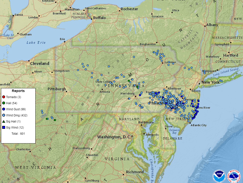
During the morning and early afternoon hours of June 3, 2020, a derecho marched across Pennsylvania, into New Jersey. The damage was first reported in Beaver Township, Clarion County, PA where it knocked down several trees. The bow-echo started to grow in size as it marched across Central Pennsylvania, downing trees and power lines across Clearfield, Tyrone, State College, Lewistown, and Hershey. As it moved into the Lehigh Valley, across the Philly Metro Area, and NJ, it was at its strongest and was very destructive.
- Length of Damage: 305 miles
- Highest Measured Wind Gust: 93 mph at Beach Haven, NJ.
- Fatalities: 4.
- Extensive tree and roof damage reported across highly populated areas of southeastern PA, and NJ.
- Later in the afternoon, another round of severe storms hit this same area, prompting a tornado warning for Philadelphia.
- Several homes that were under construction were destroyed.
- Deadliest derecho to affect this region since 1950.
Homes under construction in Philadelphia’s Port Richmond neighborhood were toppled by Wednesday’s strong derecho. A resident’s security camera caught the collapse as it happened. More: https://t.co/gg2Fx3um5X pic.twitter.com/gSWrAUd9Bd
— NBC10 Philadelphia (@NBCPhiladelphia) June 3, 2020
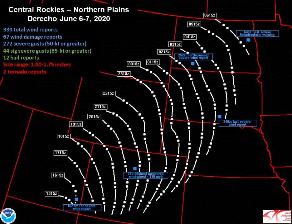
June 3, 2020: Central Rockies – Northern Plains Derecho

Rare derecho stretching from Utah to the Dakotas today.
A Rocky Mountain special. pic.twitter.com/tkNC8lLRmj
— Dakota Smith (@weatherdak) June 7, 2020
A very strong upper-level area of low pressure moved through parts of the Rockies and the Plains region on Jun 6-7, 2020. It triggered a line of storms that brought widespread damaging winds and even a few brief tornadoes to parts of Utah, Colorado, Wyoming, and the Dakotas. This event was classified as a derecho by the Storm Prediction Center. This was a rare event for this part of the country. Per a post from meteorologist Elizabeth Leitman on Twitter, there have only been two other derecho events recorded in the Western U.S: May 31, 1994, and June 1, 2002.
I put together some quick info on Saturday’s derecho event. Only two other derechoes in the Great Basin are well noted in literature. I’ve included storm reports for those events, as well as a derecho frequency map for comparison. Pretty remarkable event! #derecho #wxtwitter pic.twitter.com/d2KZk1Gvmk
— Elizabeth Leitman (@WxLiz) June 7, 2020
- Severe wind reports expanded 750 miles from far southeast Utah to southwest North Dakota.
- For nearly 12 hours, severe winds were produced.
- Derecho tracked to the northeast at approximately 60 mph.
- Highest gust was 110 mph at Winter Park Ski Area in Grand County, CO.
- A peak gust of 78 mph at the Denver airport.
- 94 mph gust at Butte, SD.
- NWS Rapid City confirmed two brief tornadoes. One was near Billsburg, SD and the other hit the Badlands/White River KOA campground in Jackson County.

#sdwx #cows Was pretty mesmerizing watching this shelf cloud with QLCS circulations embedded in it come at us. The cows were looking to us for shelter I think! pic.twitter.com/6gRhaxvuvB
— Michael Snyder (@SeattleWXGuy) June 7, 2020
August 10, 2020: Midwest Derecho
This derecho was by far the worst of the year. It was also the worst one to occur in eight years. It began in eastern Nebraska and dissipated in southern Michigan/northwestern Ohio. Iowa was by far the hardest hit, where estimated wind gusts of 140 mph caused major damage to homes, trees, corn crops, and cellphone towers. This derecho was the costliest severe thunderstorm event in US history, causing an estimated $7.5 billion in damage! It was also the second-costliest natural disaster to impact the US in 2020, falling behind Hurricane Laura, which produced $14.1 billion in damage. Cedar Rapids, IA was the hardest-hit area. It was here where the 140 mph winds tore apart a large apartment complex, destroyed half of the trees in town, and caused extensive damage to many buildings.

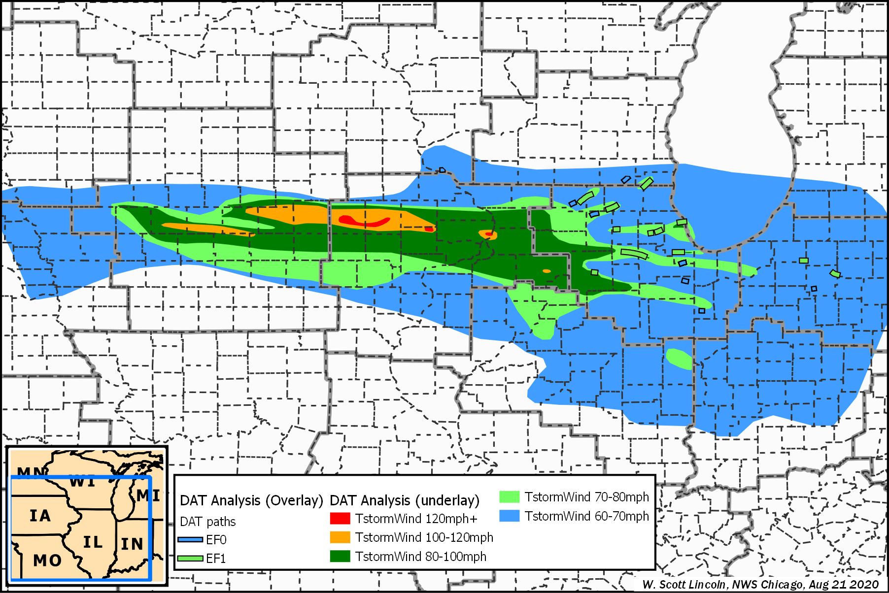
- Length of Damage: 770 miles
- Highest Measured Wind Gust: 126 mph in Atkins, IA.
- 25 tornadoes confirmed.
- 14 million acres of crops destroyed in IA.
- 100 million bushels (3.52 million cubic meters) worth of grain storage and processing infrastructure destroyed.
- Fatalities: 4, Injuries: 115.
- $7.5 billion in damage.
- 150-foot communications tower collapsed.

Sources
Derecho slams Philadelphia area with destructive 80 mph winds
Iowa derecho in August was most costly thunderstorm disaster in U.S. history
Midwest Derecho – August 10, 2020, Updated: 10/8/20 12 pm (NWS Quad Cities)
August 10, 2020: Derecho Brings Widespread Severe Wind Damage Along with Several Tornadoes (NWS Chicago)
https://en.wikipedia.org/wiki/August_2020_Midwest_derecho
Derecho Facts from The Storm Prediction Center
June 6 2020 Derecho (NWS Denver)
June 6, 2020 Derecho (NWS Cheyene)
June 6, 2020 Derecho (NWS Rapid City)
Derecho in South Dakota « CIMSS Satellite Blog
Was Saturday’s Wind Storm Colorado’s First-Ever Derecho? via The Denver Post