We love weather. No two days are the same. That fuels our passion. When weather is serious, you will hear it in our voices. No text-to-speech computer forecasts. No robotic audio. Humans connect with humans and that is what radio is all about.
Understanding Thunderstorm Risks Can Help You Prepare for Severe Weather
While most of us are still in darkness under the Groundhog’s shadow, the change in seasons will soon be underway. Every year we leave it to a rodent to make a generalized weather outlook, but the human team at the Storm Prediction Center do the real forecasting and have a lot of responsibility on their hands.
Each weather scenario is different, and when the threat of severe storms rears its ugly head, it is the job of the SPC to let us know how to plan our lives in order to remain safe.
Doing that begins with data derived from an old-fashioned yet high-tech weather balloon. From there, the business of weather gets risky.
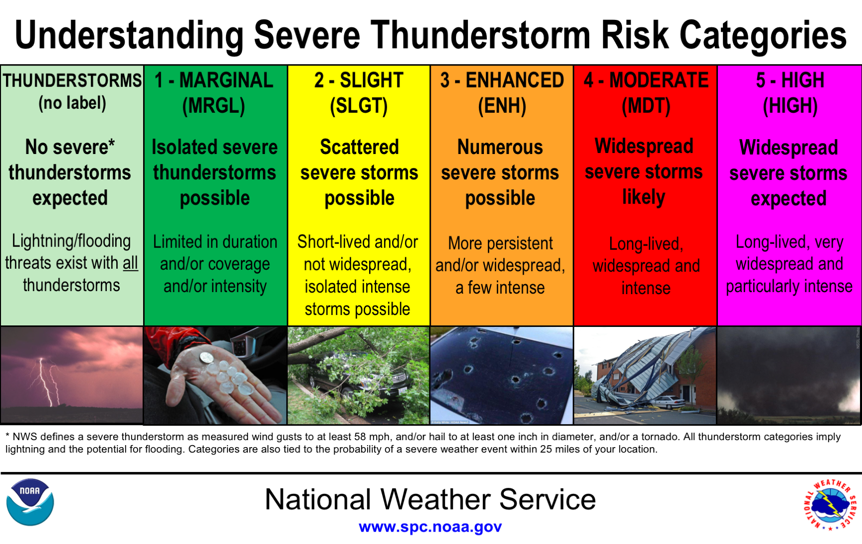
After compiling the data, the Storm Prediction Center places various areas of the country in a color-coded categorical risk. Light green means basic thunderstorms. A marginal risk is a dark green area of the map. Yellow indicates a slight risk. The fourth tier is an enhanced risk (orange). The next two levels get more attention than the others; moderate (red) and high risk (magenta).
These risks are issued up to three days out and can change over time. And while the color and their meaning seem obvious, they are a little more detailed than you might think.
Alex Forbes is an undergraduate at Mississippi State University. He told The Washington Post last year that while weather enthusiasts grasp what these risks mean, most of the general public do not. In a research project, Forbes asked 4,000 respondents to rank the order of the five categories. Those surveyed got 4 out of 5 wrong. However, most of them did understand that “high risk” means the worst level of concern.
The Storm Prediction Center uses the following criteria to help them decide what level of risk to issue when thunderstorms are possible.
The general thunderstorm risk indicates where a 10% or greater probability of thunderstorms is forecast. Usually, these storms aren’t severe.
A marginal risk means storms are likely severe but limited in organization and may not necessarily last long. The coverage is usually low, and the intensity is marginal.
A slight risk signals an area of organized severe storms, which is not widespread in coverage but might have variable levels of intensity.
The enhanced risk is fairly new and debuted in the fall of 2014. It means an area of greater severe storm coverage with intensity quite variable.
Media attention and hype rises the greater the risk becomes. That’s why extensive thought and discussion go into issuing a moderate risk. This is a region where widespread severe weather is likely, including several tornadoes and/or numerous severe thunderstorms, which should be intense. What makes the moderate more concerning is that strong tornadoes, very large hail or a widespread line of damaging winds are possible on those days.
On days when a severe weather outbreak is likely, a rare high risk is issued. It’s reserved when confidence is itself high, and damage to life and property is likely. High risks often indicate a threat of numerous strong and long tracked tornadoes or a thunderstorm complex producing hurricane-force winds over a large area.
Severe weather and tornadoes were missing from much of the country at the peak of last year’s season. If 2021 is more active, understanding the risk levels issued can help make you more prepared.
Sources:
Historic Winter Storm and Life Threatening Cold To Hit the U.S.
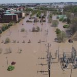
Over 100 million Americans are currently under winter-related watches, warnings, or advisories as a significant winter storm moves out of the Pacific Northwest and across the Rockies. This system will be diving through the Plains and Deep South and then moving up through the Ohio Valley and into the Northeast. The Arctic air mass we talked about in last week’s Meteo Monday continues to penetrate further southeast, so not only are we dealing with accumulating snow and ice for several areas across the country but the potential for record-breaking cold.

This storm has packed a punch across parts of the Pacific Northwest. Portions of Oregon have picked up over an inch of ice-accretion, which has led to nearly 300,000 power outages. 8-10” of snow has fallen across the Seattle Metro Area, and over a foot has fallen across the Vancouver, WA metro.
CRAZY! The weight of the snow collapses the roof of this boat dock in the Willamette River. House boats tipping, too. At the end of the vid, one man is escaping w/ what looks like a pet kennel! I hope everyone is safe. Caution: language
📷: John Kinsman around 4AM@fox12oregon pic.twitter.com/fETGx8YNzA
— Brenna Kelly (@BrennaKellyNews) February 13, 2021
The National Weather Service in Dallas, TX, is calling this a historic storm. “Major impacts resulting in severe stress to the region`s infrastructure (particularly power, water, and highways) are likely. Regional travel will be crippled for days.” They are also saying that these will be some of the region’s coldest temperatures since the December 1989 Arctic Outbreak.
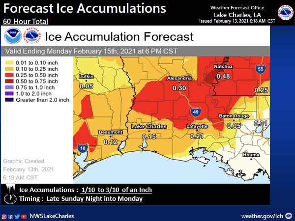
Portions of Louisiana that are still recovering from the devastating 2020 hurricane season will now have to go through a significant ice storm late Sunday night into Monday. NWS Lake Charles is projecting 0.10” to 0.30” of ice accretion across their County Warning Area (CWA). This will lead to tree damage, power outages and make driving impossible.
Below are the Weather Prediction Center (WPC) Winter Precipitation Guidance maps. These maps are valid from 7:00 AM EST Saturday through 7:00 AM EST Tuesday. They show the probability of greater than 4” of snow accumulation and ice accumulation greater than a quarter inch.


Not only are we dealing with this winter storm, but there is also a severe weather threat. The Storm Prediction Center has a slight risk (level 2 out of 5) of severe thunderstorms across portions of the Florida Peninsula for Sunday. The main threat is damaging winds, but isolated tornadoes are possible.

Sources:
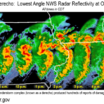
Biggest Events of 2020: Derechos
2020 supplied us with at least three large derecho events. What is a derecho? Per the Storm Prediction Center, “A derecho is a widespread, long-lived wind storm. Derechos are associated with bands of rapidly moving showers or thunderstorms variously known as bow echoes, squall lines, or quasi-linear convective systems. By definition, if the swath of wind damage extends for more than 250 miles (about 400 kilometers), includes wind gusts of at least 58 mph (93 km/h) along most of its length, and also includes several, well-separated 75 mph (121 km/h) or greater gusts, then the event may be classified as a derecho.” In our overview, we are delving into the details of the most impactful derechos of the year.
June 3, 2020: Philadelphia Derecho

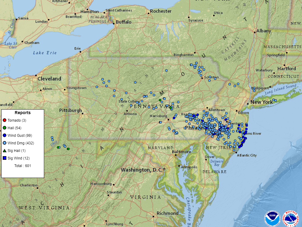
During the morning and early afternoon hours of June 3, 2020, a derecho marched across Pennsylvania, into New Jersey. The damage was first reported in Beaver Township, Clarion County, PA where it knocked down several trees. The bow-echo started to grow in size as it marched across Central Pennsylvania, downing trees and power lines across Clearfield, Tyrone, State College, Lewistown, and Hershey. As it moved into the Lehigh Valley, across the Philly Metro Area, and NJ, it was at its strongest and was very destructive.
- Length of Damage: 305 miles
- Highest Measured Wind Gust: 93 mph at Beach Haven, NJ.
- Fatalities: 4.
- Extensive tree and roof damage reported across highly populated areas of southeastern PA, and NJ.
- Later in the afternoon, another round of severe storms hit this same area, prompting a tornado warning for Philadelphia.
- Several homes that were under construction were destroyed.
- Deadliest derecho to affect this region since 1950.
Homes under construction in Philadelphia’s Port Richmond neighborhood were toppled by Wednesday’s strong derecho. A resident’s security camera caught the collapse as it happened. More: https://t.co/gg2Fx3um5X pic.twitter.com/gSWrAUd9Bd
— NBC10 Philadelphia (@NBCPhiladelphia) June 3, 2020
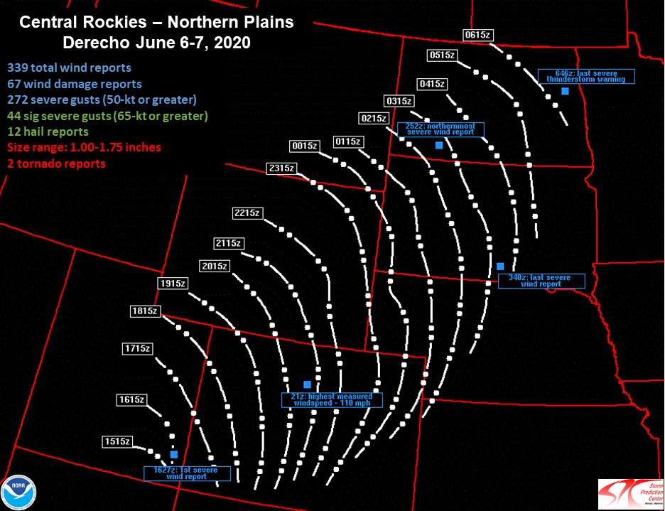
June 3, 2020: Central Rockies – Northern Plains Derecho

Rare derecho stretching from Utah to the Dakotas today.
A Rocky Mountain special. pic.twitter.com/tkNC8lLRmj
— Dakota Smith (@weatherdak) June 7, 2020
A very strong upper-level area of low pressure moved through parts of the Rockies and the Plains region on Jun 6-7, 2020. It triggered a line of storms that brought widespread damaging winds and even a few brief tornadoes to parts of Utah, Colorado, Wyoming, and the Dakotas. This event was classified as a derecho by the Storm Prediction Center. This was a rare event for this part of the country. Per a post from meteorologist Elizabeth Leitman on Twitter, there have only been two other derecho events recorded in the Western U.S: May 31, 1994, and June 1, 2002.
I put together some quick info on Saturday’s derecho event. Only two other derechoes in the Great Basin are well noted in literature. I’ve included storm reports for those events, as well as a derecho frequency map for comparison. Pretty remarkable event! #derecho #wxtwitter pic.twitter.com/d2KZk1Gvmk
— Elizabeth Leitman (@WxLiz) June 7, 2020
- Severe wind reports expanded 750 miles from far southeast Utah to southwest North Dakota.
- For nearly 12 hours, severe winds were produced.
- Derecho tracked to the northeast at approximately 60 mph.
- Highest gust was 110 mph at Winter Park Ski Area in Grand County, CO.
- A peak gust of 78 mph at the Denver airport.
- 94 mph gust at Butte, SD.
- NWS Rapid City confirmed two brief tornadoes. One was near Billsburg, SD and the other hit the Badlands/White River KOA campground in Jackson County.

#sdwx #cows Was pretty mesmerizing watching this shelf cloud with QLCS circulations embedded in it come at us. The cows were looking to us for shelter I think! pic.twitter.com/6gRhaxvuvB
— Michael Snyder (@SeattleWXGuy) June 7, 2020
August 10, 2020: Midwest Derecho
This derecho was by far the worst of the year. It was also the worst one to occur in eight years. It began in eastern Nebraska and dissipated in southern Michigan/northwestern Ohio. Iowa was by far the hardest hit, where estimated wind gusts of 140 mph caused major damage to homes, trees, corn crops, and cellphone towers. This derecho was the costliest severe thunderstorm event in US history, causing an estimated $7.5 billion in damage! It was also the second-costliest natural disaster to impact the US in 2020, falling behind Hurricane Laura, which produced $14.1 billion in damage. Cedar Rapids, IA was the hardest-hit area. It was here where the 140 mph winds tore apart a large apartment complex, destroyed half of the trees in town, and caused extensive damage to many buildings.

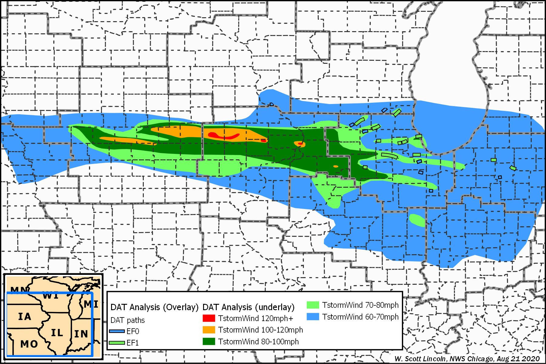
- Length of Damage: 770 miles
- Highest Measured Wind Gust: 126 mph in Atkins, IA.
- 25 tornadoes confirmed.
- 14 million acres of crops destroyed in IA.
- 100 million bushels (3.52 million cubic meters) worth of grain storage and processing infrastructure destroyed.
- Fatalities: 4, Injuries: 115.
- $7.5 billion in damage.
- 150-foot communications tower collapsed.

Sources
Derecho slams Philadelphia area with destructive 80 mph winds
Iowa derecho in August was most costly thunderstorm disaster in U.S. history
Midwest Derecho – August 10, 2020, Updated: 10/8/20 12 pm (NWS Quad Cities)
August 10, 2020: Derecho Brings Widespread Severe Wind Damage Along with Several Tornadoes (NWS Chicago)
https://en.wikipedia.org/wiki/August_2020_Midwest_derecho
Derecho Facts from The Storm Prediction Center
June 6 2020 Derecho (NWS Denver)
June 6, 2020 Derecho (NWS Cheyene)
June 6, 2020 Derecho (NWS Rapid City)
Derecho in South Dakota « CIMSS Satellite Blog
Was Saturday’s Wind Storm Colorado’s First-Ever Derecho? via The Denver Post
The Biggest Weather Events of 2020


Previous
Next
2020 was certainly a year we will never forget! And it definitely had its share of unforgettable weather events! From a historic tropical season to massive fires to an oddly quiet tornado season in Kansas, we are taking a look back at the biggest weather events of the year!
We have placed our picks in six different categories: Tornadoes, Floods, Derechos, Wildfires, The Tropics, Winter Storms. We have only been able to scratch the surface with our recap and there are many events we have missed. Let us know on Facebook or Twitter which events made your list!
Click on the category below to go to the article: