A frigid air mass has been pushing into parts of the country and you may have heard some rumblings in the news that even more cold air is on its way! Here are some of the headlines that may have graced your social media feed.
“Coldest Air of the Season Plunges into the U.S.”
“An Arctic Air Mass Will Invade the Country”
“Chunks Of The Polar Vortex Will Bring Bitterly Cold Wind Chills”
Oh no! The Polar Vortex! Is it here? AGAIN?! Run for your lives!
Yes! The Polar Vortex is here, and it is real! And we are going to talk about it in this latest version of Meteo Monday!
So, what is a polar vortex? Per the National Weather Service (NWS), “The polar vortex is a large area of low pressure and cold air surrounding both of the Earth’s poles. It ALWAYS exists near the poles, but weakens in summer and strengthens in winter. The term “vortex” refers to the counter-clockwise flow of air that helps keep the colder air near the Poles.” The vortex always exists, and it is not a new phenomenon.
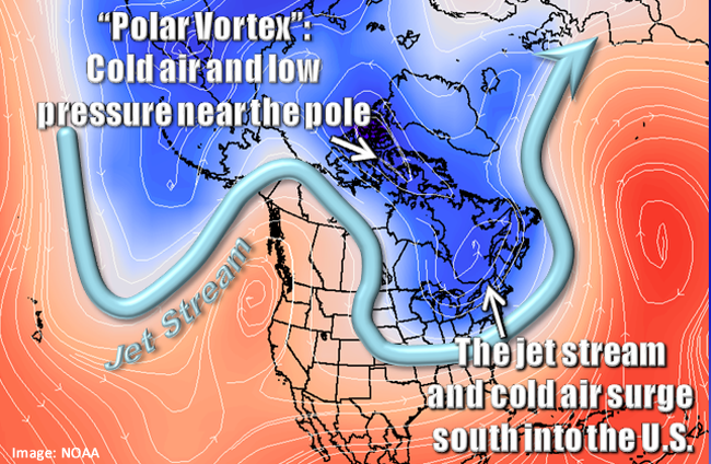
Winter for a good part of the United States is…cold. However, there are times where it gets much colder than average. Plunges of arctic air masses are caused when the jetstream links up with a piece of the polar vortex and pulls the frigid air southward into the lower 48. Using the term polar vortex to describe these cold shots became mainstream in the winter of 2013/2014 when the national media ran headlines about it. Since then, every cold snap has been labeled “polar vortex.” It is important to stress that this is not a new term and that meteorologists started using the phrase in 1853!
Why do you see these news headlines about the polar vortex? First of all, The Climate Prediction Center (CPC) 6-10 day outlook over the past few weeks, has consistently shown temperatures across a good part of the country well below average.

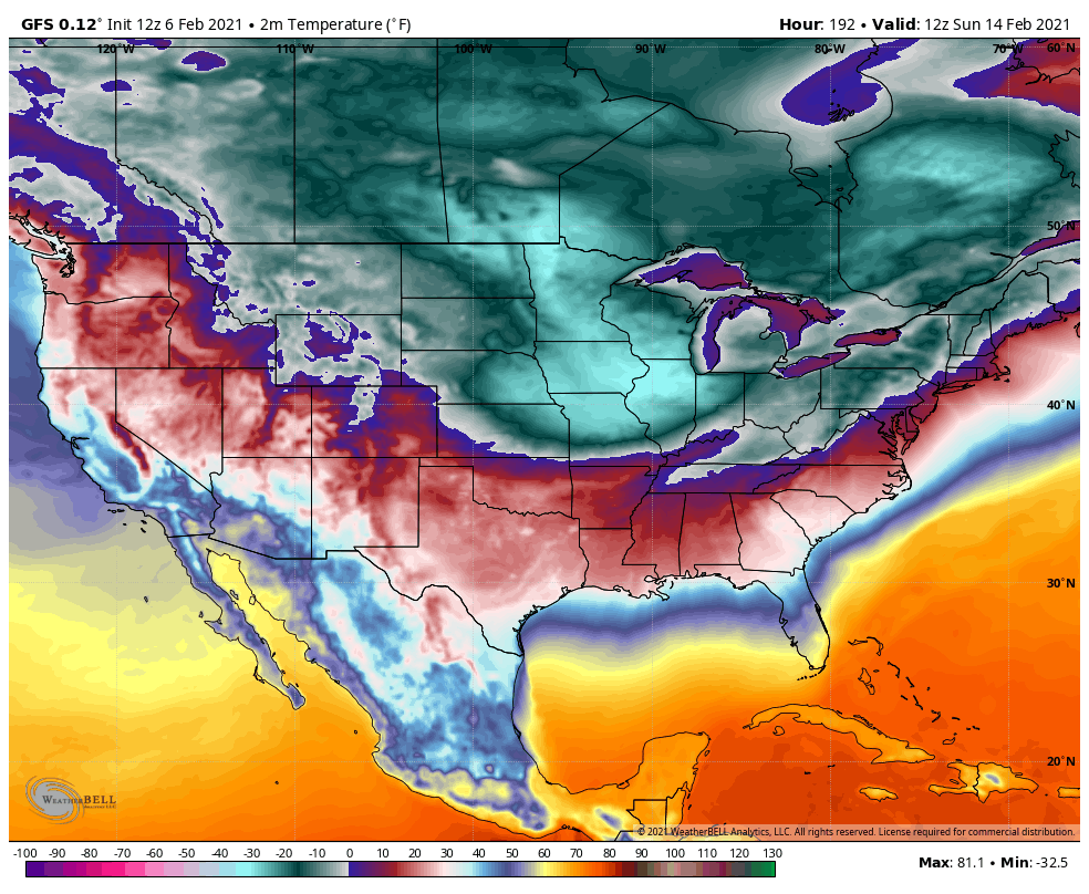
Current weather computer models show that the coldest temperatures will likely occur just before sunrise on Valentine’s Day. We want to stress that this is not a forecast, it is a model’s interpretation, and things have changed and will continue to do so as we are still several days away. It is difficult to forecast who will get the coldest air. We have been looking at the model runs for the past several days. They continue to show that frigid temperatures will seep further south. But where exactly will this set up?
Take a look at the Global Forecast System (GFS Model) slated for 12z (7:00 am EST on the 14th). The image at the top shows the forecast from Saturday, February 6, and the image at the bottom shows the forecast from today (February 8). Notice a shift in where the coldest air will be based on the model runs. Saturday’s run had the arctic air stretching from the Northern and Central Plains eastward into the parts of the Ohio Valley and the Northeast. Today’s model interpretations are showing the coldest air much further west. This air mass is forecast to stay from west of the Mississippi River through the Northern and Central Plains and over the Rockies. Also a nose of colder air could settle into Texas and New Mexico.

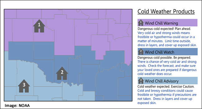
No matter how cold it gets, it is essential each winter season to review your safety plan. Arctic blasts typically occur each season, some worse than others. And some lasting longer than others. Arctic air combined with brisk winds can lead to extremely cold wind chill temperatures. Per the NWS, “The wind chill temperature is based on the rate of heat loss from exposed skin caused by wind and cold and is to give you an approximation of how cold the air feels on your body.” The NWS issues Wind Chill products to alert the public of dangerous cold.
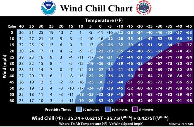
When venturing outside in the extreme cold, make sure to dress in layers. One of the dangers of the bitter cold is frostbite. Per the NWS, “Frostbite happens when the body’s survival mechanisms kick in during extremely cold weather. To protect the vital inner organs, the body cuts circulation to your extremities: feet, hands, nose, etc., which eventually freeze.” If you have to go out, make sure to cover every part of your body. Stay out of the wind and limit your time outside. Frostbite can occur within five minutes when wind chill values are -50°F or below. If your body temperature lowers to below 96°F, you have hypothermia. This is a severe health condition, and you must seek medical attention immediately.
Other things to consider when an arctic air mass is on its way: Protect your pets or farm animals. Limit their exposure to the cold and make sure they have plenty of food and water. Take precautions to keep the pipes at your home or business from freezing. Keep at least a half tank of gas in your vehicle and prepare a winter car survival kit. Items to include: jumper cables, a flashlight, first aid kit, a shovel and ice scraper, extra clothes, and blankets.
So, whether the headline includes the words “polar vortex” or some other frigid phrase, remember it is winter, and periods of extreme cold are nothing new. The goal is to be prepared and stay safe. Think warm! Meteorological spring is only a few weeks away!
Sources: