When your community hosts special events, the weather is always a factor. We weave timely information into your forecast when it comes to fairs, parades, fundraisers or remote broadcasts. If your weather is sponsored, we are the spokesperson, helping your client earn results.
Getting Ready For Severe Weather Season!
It’s official, today is the first day of Meteorological Spring, and you know what that means; we start thinking about spring storms and the risk of severe weather. There are some important things to address before the storms start firing up. What is the difference between a watch and a warning? What are the different ways to receive these warnings? What do you need to do to stay safe? We will find out in this week’s Meteo Monday.

Watch VS Warning
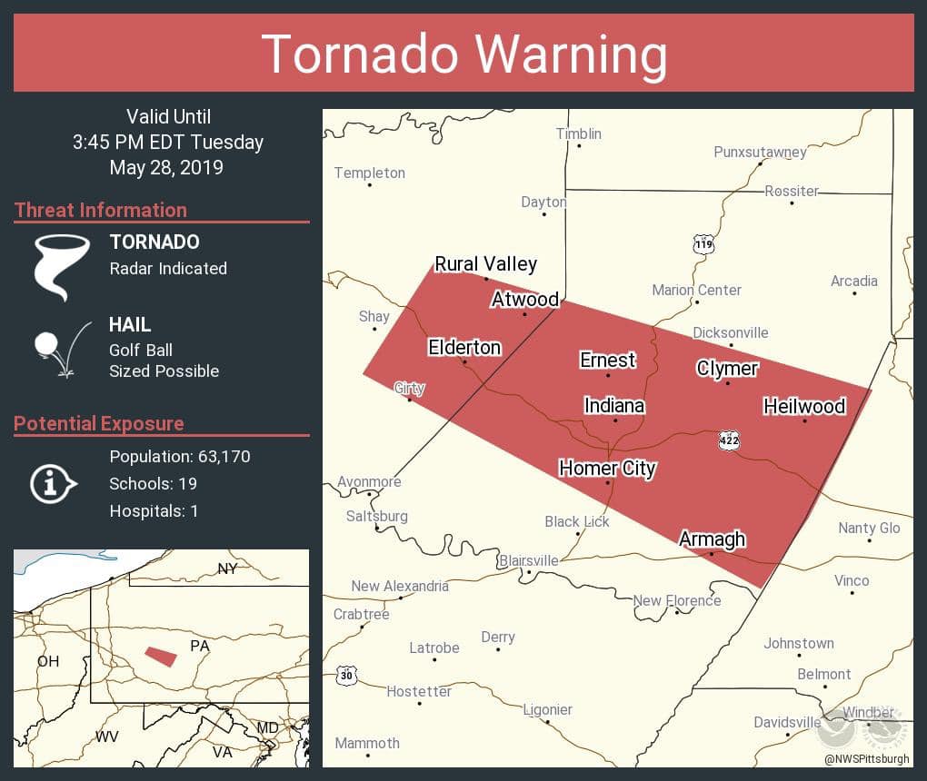
The two main types of watches issued during severe weather season are severe thunderstorm and tornado watches. The Storm Prediction Center (SPC) issues these watches. A watch is issued when conditions are ripe for severe storm development. If the conditions in place suggest the primary storm mode will be tornadic storms, the SPC will opt for a tornado watch instead of a severe thunderstorm watch.
A watch means that dangerous storms are expected to happen within a particular area; though one thing to note, it doesn’t mean everyone inside the watch box will get a bad storm. When a watch is issued, you can go on about your daily routine; but, you should pay closer attention to the weather that is going on, and you should be prepared to seek shelter if the watch is upgraded to a warning.


A warning is issued when severe weather is occurring or imminent. Warnings are issued by local National Weather Services (NWS) offices. Per the NWS, a severe thunderstorm warning will be issued if the storm is capable of producing at least one of the following criteria: “winds of at least 58 mph (50 knots or ~93 km/h), and/or hail at least 1″ in diameter.” Just because a storm is producing a lot of lightning doesn’t automatically make it a severe storm. A warning will not be issued unless one of the above criteria is being indicated by radar.
It is also possible to have a severe thunderstorm warning without having any lightning or thunder. If a line of showers reaches the above criteria, a severe thunderstorm warning will be issued. This happens fairly frequently across the Mid-Atlantic, in the early spring and late fall, when you get a low-topped squall line that forms along a cold front. These often produce damaging winds over 70 mph but usually produce little to no thunder and lightning.
Another thing to note is that in some cases if there is broad, weak rotation in a storm, a “tornado possible tag” is added to the warning. If a severe thunderstorm is showing signs of strong rotation, a tornado warning will be issued. Severe thunderstorm warning criteria do not need to be met for this. As long as the storm is showing signs of strong rotation on the radar, a tornado warning will be issued.

How to Receive Warnings
When it comes to receiving severe thunderstorm and tornado warnings, it is recommended that you have more than one way to obtain the warnings. If the cell phone towers go out, you might not be able to receive alerts that way, or perhaps the tornado sirens in town aren’t working. So you shouldn’t be relying on one method.
Arguably the best way to receive warnings is from the NOAA Weather Radio. You can pick up a weather radio for as low as $20 from your local Walmart, or you can choose from several different models online. This has been a tried and tested method since the late 1970s. The loud sounds that these emit before reading you the warning are loud enough to wake you if there is a nighttime severe weather warning.

Smartphones are another great way to receive warnings. All modern phones are equipped to receive Wireless Emergency Alerts (WEA). The WEA will sound for tornado warnings, snow squall warnings, and hurricane warnings. If a tornado warning is issued for the area you are in; it will ping the cell phone tower you’re connected to and then transmit to your phone. You shouldn’t rely just on the WEA on your phone; you should have another app on your phone to receive other warnings for flooding, severe thunderstorms, or even winter weather. We recommend the FEMA app, which will send any type of weather alert to your phone. You can download the FEMA app here for iPhone or here for Android. The FEMA app also lets you monitor several locations, so you can keep tabs on alerts that may come across for family members on the other side of the country! You can also download an app from your favorite local news station and use that as a way to receive push notifications for severe alerts.

When you think of a tornado warning, you might instantly think of tornado sirens. These are a staple in the tornado-prone communities of the United States. These, however, are the least reliable method of receiving a warning. Tornado sirens can often go out during severe weather due to power outages and lightning strikes. Their sound can also be obscured by the sound of pounding rain/hail and even the roar of a tornado itself. A tornado siren is NOT meant to be heard inside, so if you rely on this as your primary indicator to seek cover, you should really consider one of the options we have mentioned above. Tornado sirens are intended to warn people outside, such as people at a baseball park. One thing to keep in mind is that the NWS has no control over these sirens. They are controlled by the county or city emergency management agency (EMA). Each location may have different criteria on when to sound the sirens.

Severe Weather Safety
Now that we know the differences between a watch and a warning and how to receive the alert, what do you need to do when one is issued? The first thing to do is stay calm.
Secondly, go to your shelter. The best place to be is underground, in a basement, or a storm cellar, if you are at home. But where should you go if you don’t have an underground shelter? Go to the lowest part of the house, and get into an interior closet or bathroom, preferably one without windows. Put as many walls between you and the outside as possible. Newer homes that are being built in tornado-prone areas have above-ground tornado shelters. These are being used for bedroom closets, pantries, and even bathrooms and are designed to withstand violent tornadoes and offer protection even if the rest of the house is blown away. Regardless of the location in the house, you’re sheltering, you should make sure to have the following to keep you safe:
- Sturdy shoes or boots
- Blankets or pillows to cover yourself with
- A helmet to protect your head
- A radio or cell phone to get the latest warning updates
- An air horn. If you are trapped, you can use this to help the rescuers locate you
LIVES SAVED by a tornado shelter from the violent tornado that tore through Moss, MS. Family of 4 hunkered down in concrete saferoom. @Tornado_Safe https://t.co/CMTZEtZrXw
— Reed Timmer (@ReedTimmerAccu) April 13, 2020
But, what if you live in a mobile or manufactured home? According to the NWS, mobile homes offer no safe shelter in severe thunderstorms or tornadoes, and following the above protocols for a house is meaningless. They recommend evacuating the home and going to a more substantial shelter, which could be a neighbor’s house, a grocery store, or even a community storm shelter. They also recommend people in mobile homes executing their safety plans when a tornado watch is issued and not waiting for it to be upgraded to a warning.
The above tips are great, but what happens if you’re not at home? Perhaps you are at work, at the store, or at a restaurant? Thankfully most places have severe weather protocols in place. These protocols are very similar to sheltering in a house. Getting in the basement is preferable, but if the location doesn’t have one, put as many walls between you and the outside as possible. Many of these businesses have signs to show patrons where the tornado shelters are.

Finally, what should you do if you are driving down the highway when your WEA starts going off? If you’re able to, take the next exit and take cover in the closest business you can find. If you do not have time to get to the next exit, the NWS recommends that you leave your car and take cover in a ditch or culvert as a last resort. Park your vehicle on the opposite of the road (so it doesn’t get blown onto you). Lie as flat to the ground as you can. You will be exposed to flying debris, rain, and hail, so if you have anything in your car, such as a pillow or a backpack that you can use to protect your head, use it. You should never take shelter under a highway overpass and should be avoided at all costs. These act as wind tunnels and funnel the wind and debris through them.

With severe weather season upon us, it is crucial to have a severe weather plan in place and know what to do before the storm strikes. If you don’t have a plan, make one now, and encourage your friends and family to have a plan as well.
Sources:
Meteo Monday – Unique Cloud Types
Have you ever stepped outside and looked up into the sky to see what looks like a UFO shaped-cloud? What about clouds that look like waves? In this week’s Meteo Monday, we are getting our “head out of the clouds” and delving into the meteorology of unique cloud types.

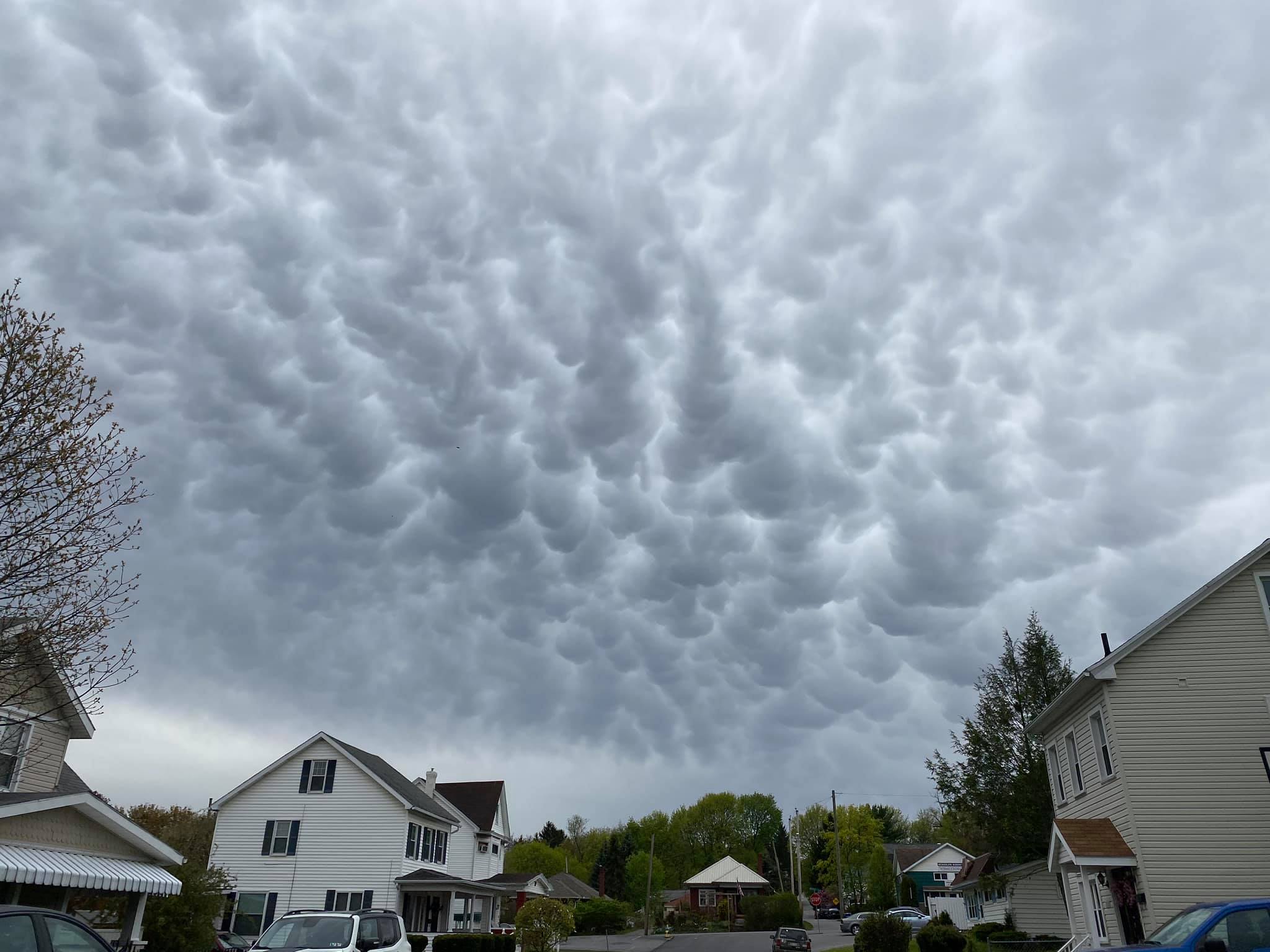
Mammatus Clouds
Mammatus clouds are often seen during severe thunderstorms. The name mammatus is derived from the Latin “mamma,” meaning “udder or breast” and can be thought of as “mammary clouds.” These clouds can be very ominous looking, and there is uncertainty on how they are created. One hypothesis suggests that they are formed when there is a lot of wind shear (the changing of wind direction or wind speed with height) along with sharp gradients in temperature and moisture.
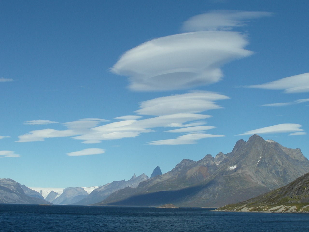
Lenticular Clouds
Lenticular clouds look like UFOs that form in hilly or mountainous areas. These form when moist, stable air flows over an eddy, usually caused by mountains or hills. If the dewpoint and temperature meet and condensation occurs, as the air moves through this eddy, a lenticular cloud is formed, often on the leeward side of the mountain. Some people believe that these clouds are responsible for UFO sightings.
Arcus Clouds
Arcus clouds are low-horizontal cloud formations that often are associated with storm clouds. Many people are familiar with shelf clouds that form along the gust front or leading edge of a severe thunderstorm. Shelf clouds are just one type of arcus cloud. Another type is called a roll cloud. This is similar to a shelf cloud, but it is not attached to a cloud base. They can form with sea breezes and cold fronts without thunderstorms present.

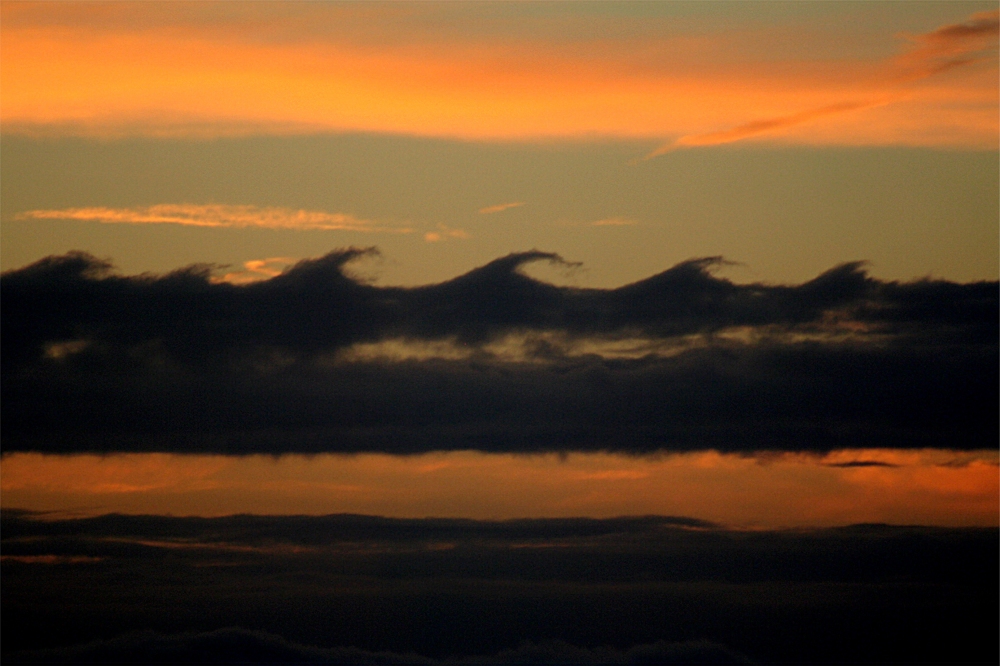
Kelvin-Helmholtz Instability Clouds
The name of this cloud type is a mouth-full “Kelvin-Helmholtz Instability Clouds.” These rare clouds get their name from the physicists who studied turbulent airflow, Hermann Helmholtz and Lord Kelvin. They can occur on windy days when you have different wind speeds at different heights. Per the UK Met Office: “When the upper layer of air is moving at a higher speed than the lower-level air, it may scoop the top of an existing cloud layer into these wave-like rolling shapes. Kelvin-Helmholtz instability is a scientific phenomenon not exclusively associated with clouds.”
Have you seen any of these clouds we talked about in our article? If so send us your photos to our Facebook and Twitter @thestormreport or use the hash-tag: #meteomonday.
Sources:
St. Elmo’s Fire!
One of my movie-star crushes from the 80s was Rob Lowe. (I know I just aged myself). He was a member of the brat pack and one of the stars of the 1985 coming of age movie, St. Elmo’s Fire. The plot revolves around a group of recent graduates from Georgetown University trying to navigate the waters of life after college. In one scene, Rob’s character Billy is attempting to help his friend Jules, played by Demi Moore, through her breakdown. He tells her that the drama she is in the midst of isn’t real. It is just like St. Elmo’s Fire. He then explains this phenomenon as “electric flashes of light that appear in dark skies out of nowhere. Sailors would guide entire journeys by it, but the joke was on them, there was no fire, there wasn’t even a St. Elmo. They made it up.”
https://www.youtube.com/watch?v=20GcL1nyzE8
Hold the presses, Billy! This meteorologist must object! St. Elmo’s Fire is a real phenomenon, and there was a St. Elmo. Let’s look a little deeper, shall we?
St Elmo's Fire on the windshield of a passenger jet last night as it passed south of the Fultondale storm/tornado last night. Photo from Ziggy Jirik pic.twitter.com/AKT1Egg6N9
— James Spann (@spann) January 27, 2021
Per NOAA, “St. Elmo’s Fire is a colorful discharge of atmospheric electricity that typically occurs during a thunderstorm. When a sharp object (such as a ship’s mast) comes in contact with an extraordinarily high electrical field and a large number of electrons, the electrons can glow in various colors, like a neon sign, resulting in this rare phenomenon.” The glow is a blue or violet color, and the sharp object could also be spires, chimneys, and even aircraft wings.
https://youtu.be/Lgv-3ITbOm4
Billy was on the right track about sailors and their connection to St. Elmo’s Fire. But he was incorrect in stating there was not a St. Elmo. One of the patron saints of sailors was St. Erasmus of Formia, also known as Elmo. He was an early Christian bishop and martyr.

How did Elmo become a saint to the sailors? During my research on this topic, I found a story stating that Erasmus was preaching, and lightning struck the ground near him. He survived. Sailors began to believe that Elmo could protect them from storms while at sea. During a thunderstorm, that “colorful discharge of atmospheric electricity” would sometimes be seen on a masthead. Sailors would see that as the presence of Elmo. The phenomenon, St. Elmo’s Fire, is named after St. Erasmus.
Typically, paintings depicting Elmo (like the one above) show him holding a windlass, an apparatus for hoisting heavy weights. On a boat, it can be used to help raise an anchor. This icon also signifies Elmo as a patron of sailors.
St. Elmo’s Fire was observed during a tornado outbreak in 1955. In an article entitled, “Storm Electricity Aspects of the Blackwell/Udall Storm of 25 May 1955”, Don Burgess documents the “unusually vigorous electrical activity” seen during this event. Burgess was 8-years-old and observed the storm’s early life from the western edge of Stillwater, OK. He notes, “Later, as the nighttime Blackwell tornado formed south-southeast of Tonkawa, it was made visible by frequent lightning flashes. At Blackwell, very frequent cloud-to-ground lightning was observed ahead of the tornado, and unusual electrical activity was seen in and around the tornado. Very bright electrical discharges were seen within the funnel and ground-originating corona current (also known as St. Elmo’s Fire) was seen just ahead of the tornado.”
Sources:
Top Five: Weird Ocean Phenomena – NOAA
Who are the Three Patron Saints of Sailors? – Elmo, Christopher and Brendan
Meteo Monday – The Polar Vortex!
A frigid air mass has been pushing into parts of the country and you may have heard some rumblings in the news that even more cold air is on its way! Here are some of the headlines that may have graced your social media feed.
“Coldest Air of the Season Plunges into the U.S.”
“An Arctic Air Mass Will Invade the Country”
“Chunks Of The Polar Vortex Will Bring Bitterly Cold Wind Chills”
Oh no! The Polar Vortex! Is it here? AGAIN?! Run for your lives!
Yes! The Polar Vortex is here, and it is real! And we are going to talk about it in this latest version of Meteo Monday!
So, what is a polar vortex? Per the National Weather Service (NWS), “The polar vortex is a large area of low pressure and cold air surrounding both of the Earth’s poles. It ALWAYS exists near the poles, but weakens in summer and strengthens in winter. The term “vortex” refers to the counter-clockwise flow of air that helps keep the colder air near the Poles.” The vortex always exists, and it is not a new phenomenon.
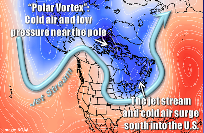
Winter for a good part of the United States is…cold. However, there are times where it gets much colder than average. Plunges of arctic air masses are caused when the jetstream links up with a piece of the polar vortex and pulls the frigid air southward into the lower 48. Using the term polar vortex to describe these cold shots became mainstream in the winter of 2013/2014 when the national media ran headlines about it. Since then, every cold snap has been labeled “polar vortex.” It is important to stress that this is not a new term and that meteorologists started using the phrase in 1853!
Why do you see these news headlines about the polar vortex? First of all, The Climate Prediction Center (CPC) 6-10 day outlook over the past few weeks, has consistently shown temperatures across a good part of the country well below average.

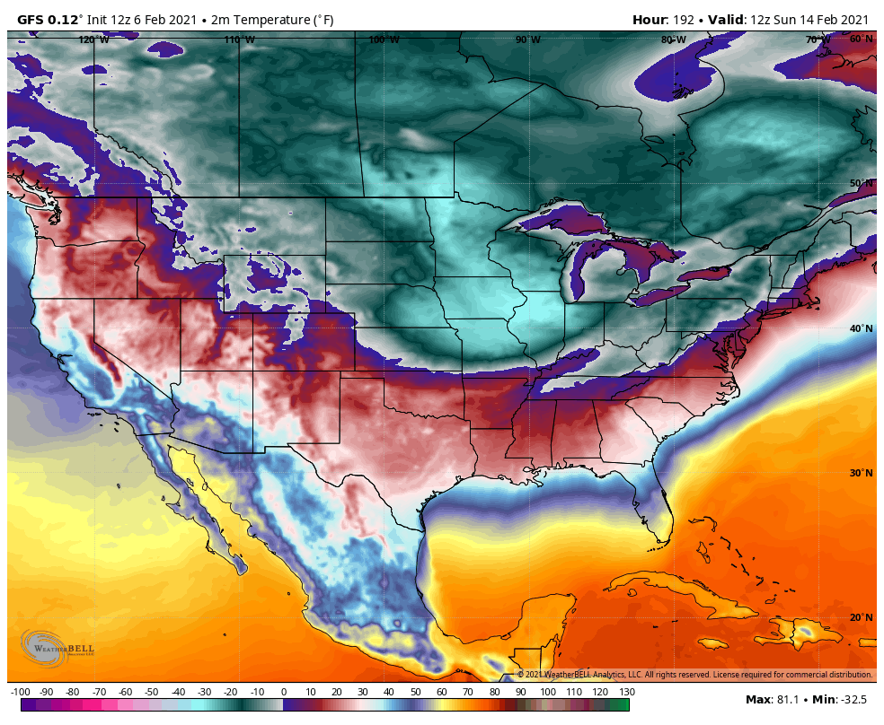
Current weather computer models show that the coldest temperatures will likely occur just before sunrise on Valentine’s Day. We want to stress that this is not a forecast, it is a model’s interpretation, and things have changed and will continue to do so as we are still several days away. It is difficult to forecast who will get the coldest air. We have been looking at the model runs for the past several days. They continue to show that frigid temperatures will seep further south. But where exactly will this set up?
Take a look at the Global Forecast System (GFS Model) slated for 12z (7:00 am EST on the 14th). The image at the top shows the forecast from Saturday, February 6, and the image at the bottom shows the forecast from today (February 8). Notice a shift in where the coldest air will be based on the model runs. Saturday’s run had the arctic air stretching from the Northern and Central Plains eastward into the parts of the Ohio Valley and the Northeast. Today’s model interpretations are showing the coldest air much further west. This air mass is forecast to stay from west of the Mississippi River through the Northern and Central Plains and over the Rockies. Also a nose of colder air could settle into Texas and New Mexico.

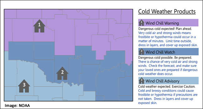
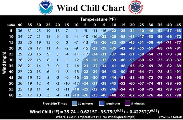
No matter how cold it gets, it is essential each winter season to review your safety plan. Arctic blasts typically occur each season, some worse than others. And some lasting longer than others. Arctic air combined with brisk winds can lead to extremely cold wind chill temperatures. Per the NWS, “The wind chill temperature is based on the rate of heat loss from exposed skin caused by wind and cold and is to give you an approximation of how cold the air feels on your body.” The NWS issues Wind Chill products to alert the public of dangerous cold.
When venturing outside in the extreme cold, make sure to dress in layers. One of the dangers of the bitter cold is frostbite. Per the NWS, “Frostbite happens when the body’s survival mechanisms kick in during extremely cold weather. To protect the vital inner organs, the body cuts circulation to your extremities: feet, hands, nose, etc., which eventually freeze.” If you have to go out, make sure to cover every part of your body. Stay out of the wind and limit your time outside. Frostbite can occur within five minutes when wind chill values are -50°F or below. If your body temperature lowers to below 96°F, you have hypothermia. This is a severe health condition, and you must seek medical attention immediately.
Other things to consider when an arctic air mass is on its way: Protect your pets or farm animals. Limit their exposure to the cold and make sure they have plenty of food and water. Take precautions to keep the pipes at your home or business from freezing. Keep at least a half tank of gas in your vehicle and prepare a winter car survival kit. Items to include: jumper cables, a flashlight, first aid kit, a shovel and ice scraper, extra clothes, and blankets.
So, whether the headline includes the words “polar vortex” or some other frigid phrase, remember it is winter, and periods of extreme cold are nothing new. The goal is to be prepared and stay safe. Think warm! Meteorological spring is only a few weeks away!
Sources:
- 1
- 2
- 3
- …
- 6
- Next Page »