When your community hosts special events, the weather is always a factor. We weave timely information into your forecast when it comes to fairs, parades, fundraisers or remote broadcasts. If your weather is sponsored, we are the spokesperson, helping your client earn results.
Real Passion
We love weather. No two days are the same. That fuels our passion. When weather is serious, you will hear it in our voices. No text-to-speech computer forecasts. No robotic audio. Humans connect with humans and that is what radio is all about.
Real Personalities
When looking to add a trusted source for weather, you want someone who can connect with your audience. Our meteorologists are also on-air personalities. The Storm Report team delivers a fresh sound with relatable information to get through the day. We are your staff meteorologists.
What is a PDS watch?

Severe thunderstorm and tornado watches are quite common. Every spring and summer, thunderstorms can become strong to severe. When storms produce hail at least one-inch or greater and/or contain strong winds 58 mph hour or higher, a severe thunderstorm watch is issued. If we add a tornado probability to the wind and hail concerns, a tornado watch is issued. The watch means conditions are favorable for severe thunderstorms or tornadoes in and close to the watch area.
There are times, and it is rare, when severe weather can be significant, posing a greater threat to life and property. That’s when the Storm Prediction Center will enhance the wording in a weather watch and include “Particularly Dangerous Situation”.

PDS tornado watches are put into effect when the forecaster has high confidence that multiple strong tornadoes will occur in the watch area. PDS severe thunderstorm watches likely mean there is a threat of a high end derecho with widespread wind damage.
Just how unusual is the PDS watch? According to the Cooperative Institute for Meteorological Studies at the University of Oklahoma, of 3058 tornado watches issued from 1996-2005, just 7% were labeled “PDS”. Most of the 216 “particularly dangerous situation” tornado watches covered the lower Mississippi Valley with the Plains states coming in second.
The study says the motivation for using the PDS wording is to communicate to the public the significance of the severe weather threat. EF2-EF5 tornadoes represent less than 10% of all tornado reports, yet they produce over 90% of the fatalities and 80% of the injuries and damage.
Understanding Thunderstorm Risks Can Help You Prepare for Severe Weather
While most of us are still in darkness under the Groundhog’s shadow, the change in seasons will soon be underway. Every year we leave it to a rodent to make a generalized weather outlook, but the human team at the Storm Prediction Center do the real forecasting and have a lot of responsibility on their hands.
Each weather scenario is different, and when the threat of severe storms rears its ugly head, it is the job of the SPC to let us know how to plan our lives in order to remain safe.
Doing that begins with data derived from an old-fashioned yet high-tech weather balloon. From there, the business of weather gets risky.
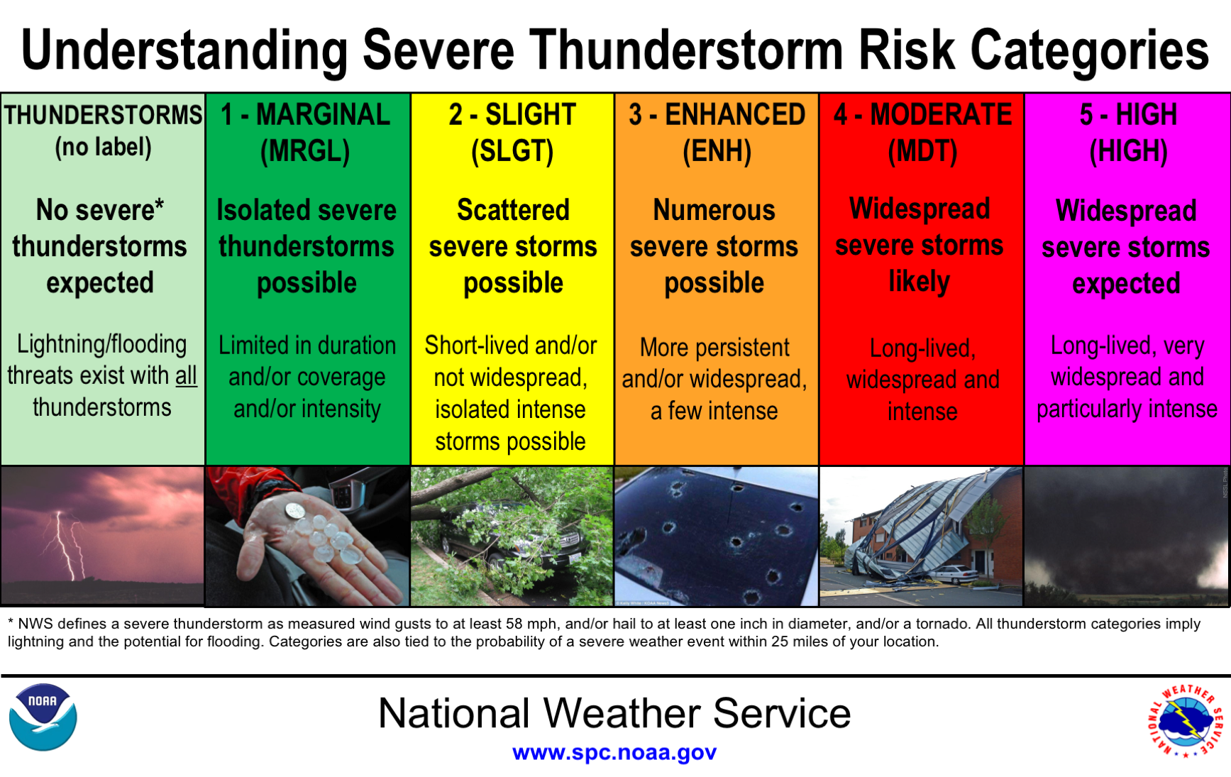
After compiling the data, the Storm Prediction Center places various areas of the country in a color-coded categorical risk. Light green means basic thunderstorms. A marginal risk is a dark green area of the map. Yellow indicates a slight risk. The fourth tier is an enhanced risk (orange). The next two levels get more attention than the others; moderate (red) and high risk (magenta).
These risks are issued up to three days out and can change over time. And while the color and their meaning seem obvious, they are a little more detailed than you might think.
Alex Forbes is an undergraduate at Mississippi State University. He told The Washington Post last year that while weather enthusiasts grasp what these risks mean, most of the general public do not. In a research project, Forbes asked 4,000 respondents to rank the order of the five categories. Those surveyed got 4 out of 5 wrong. However, most of them did understand that “high risk” means the worst level of concern.
The Storm Prediction Center uses the following criteria to help them decide what level of risk to issue when thunderstorms are possible.
The general thunderstorm risk indicates where a 10% or greater probability of thunderstorms is forecast. Usually, these storms aren’t severe.
A marginal risk means storms are likely severe but limited in organization and may not necessarily last long. The coverage is usually low, and the intensity is marginal.
A slight risk signals an area of organized severe storms, which is not widespread in coverage but might have variable levels of intensity.
The enhanced risk is fairly new and debuted in the fall of 2014. It means an area of greater severe storm coverage with intensity quite variable.
Media attention and hype rises the greater the risk becomes. That’s why extensive thought and discussion go into issuing a moderate risk. This is a region where widespread severe weather is likely, including several tornadoes and/or numerous severe thunderstorms, which should be intense. What makes the moderate more concerning is that strong tornadoes, very large hail or a widespread line of damaging winds are possible on those days.
On days when a severe weather outbreak is likely, a rare high risk is issued. It’s reserved when confidence is itself high, and damage to life and property is likely. High risks often indicate a threat of numerous strong and long tracked tornadoes or a thunderstorm complex producing hurricane-force winds over a large area.
Severe weather and tornadoes were missing from much of the country at the peak of last year’s season. If 2021 is more active, understanding the risk levels issued can help make you more prepared.
Sources: