Just about everyone has heard of El Niño. But what about its opposite, La Niña? What is this climatological phenomenon? How does it work? And, what effect will it have on our weather over the next few months?
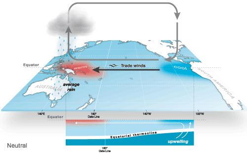
La Niña is just one phase of the “El Niño Southern Oscillation”, or “ENSO”, which is a pattern of air pressure and ocean currents across the Central Pacific Ocean. The opposite of La Niña is El Niño. In between is what we call the “neutral” phase. In between those are the “transitional” phases. El Niño is the warm phase of this circulation, with relatively warm water piling up in the Eastern Pacific, while La Niña is the cool phase.
ENSO doesn’t just affect the Eastern Pacific though. It’s one of the most influential circulations in North American weather.
The National Oceanic And Atmospheric Administration (NOAA), along with other worldwide scientific agencies, monitor ocean temperatures and air pressure constantly. They do this in order to determine which phase of ENSO we’re in, and roughly how long it is expected to stay in that phase, or change back to the opposite phase.
This back and forth pattern has been known for centuries. Thanks to modern technology, including satellite data and automated ocean buoys, it can be tracked and predicted more accurately than ever.
The oscillation isn’t really predictable in the long term. We may see a La Niña go from neutral, then right back to La Niña, or stay in an El Niño phase for several seasons. Or, it may stay neutral for a while. Or, we might see a “mild” or “super” phase.
According to recent data from the Climate Prediction Center (CPC), La Niña is in full swing, with good chances of it staying in place through March 2021. Here’s a look at what this might portend for the average weather this winter. These are the latest climate maps for the next month, from the CPC.


Here’s a quick look at how ENSO works. During a La Niña, we get colder ocean water piling up in the Eastern Pacific. This will tend to cause an east-to-west flow of air along the Equator. This is because cold air is more dense, with higher surface pressure, and will tend to flow toward lower pressure. The movement of air also contributes to the movement of the ocean water below, and vice-versa, in a feedback loop.
With La Niña, wind blowing from east to west will move surface water from the Eastern Pacific. So, colder water from below will rise up to replace it, causing a loop which continues until the pattern is disrupted.
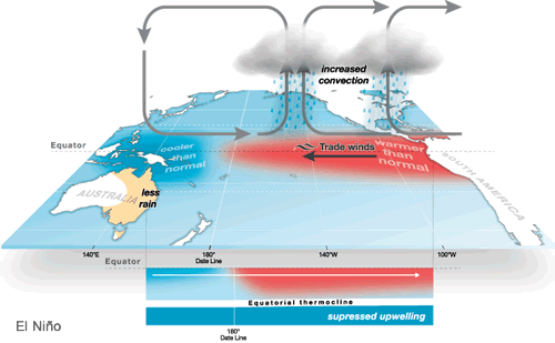
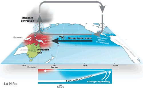
The opposite holds true for El Niño, with warmer water in the Eastern Pacific, and a west-to-east atmospheric flow. The warmer water near western North America will tend to cause lower air pressure, bringing more favorable conditions for formation and precipitation for the southwestern and southern parts of the country. With La Niña, we get cooler air and water, which suppresses cloud development, and thus, less rain over those regions.
Things get tricky with these changes, because different effects will be felt over different regions of the USA. While the western and southern states are often more dry and warm during a La Niña, the northern and eastern regions may get an increase in precipitation and a decrease in temperature. During El Niño, it may be the opposite.
Keep in mind, when we talk about warmer or colder, and wetter and drier, that refers to “seasonal averages”, since each phase of ENSO usually lasts for several months. So, blaming ENSO for any one short-term weather event is usually not a good idea.
Also keep in mind that ENSO is just one of many regularly-occurring ocean/atmosphere circulations around the world, which affect our weather in the United States. But, ENSO tends to get the most attention, since the impacts are usually more evident over three-month periods.
That brings us to the current situation. The CPC started seeing indications last summer of an approaching La Niña phase. Now that sea surface temperatures and other data have confirmed the things, a “La Niña Advisory” has been issued by the CPC.
From their powerpoint presentation of November 16, 2020: “La Niña conditions are present. Equatorial sea surface temperatures are below average from the west-central to the eastern Pacific Ocean. The tropical atmospheric circulation is consistent with La Niña. La Niña is likely to continue through the Northern Hemisphere winter, 2020-2021.”
They indicate a 95% chance that La Niña will be present from January through March, and a 65% chance of it continuing into spring of next year. NOAA and other scientific agencies not only measure sea-surface temperature, but also at various depths. Likewise, while surface winds are measured, wind direction and speed are also measured higher up, to determine the strength of the ENSO phase.
With the onset of a La Niña winter, generally speaking, we can expect a warmer, drier weather pattern for the western and southern states, and somewhat cooler and wetter conditions for the northern and eastern areas.
The CPC provides a seasonal outlook, and also a month-by-month prediction of weather trends, largely based on the ENSO circulation. But keep in mind that other atmospheric trends come into play. In other words, La Niña won’t control our weather completely.
We mentioned before that while ENSO definitely has an impact on regional weather across the country, it’s measured or observed, then averaged-out on a seasonal basis, or over the duration of the ENSO phase. That means, short-term weather isn’t predicted simply based on whether we’re in a La Niña, Neutral or El Niño.
In fact, over the years, trends have been observed that are exactly opposite what we’d expect from a certain ENSO phase, usually due to other contributing factors well away from North America. All of the various circulations are interwoven, or “teleconnected”. That is to say, predicting an oncoming ENSO phase is usually easier than predicting the daily weather for any given city.
To sum it all up, heading into a La Niña winter, we should, on average, see more precipitation and cooler weather for the northern and eastern states, and warmer, drier weather for the south and west. You can track all of this by looking up The Climate Prediction Center online. Their site is constantly updated with seasonal rainfall and temperature forecasts.
Sources:
Climate Prediction Center (One-Month Outlooks & Winter Outlook and Graphics) La Nina specifications, La Nina Advisory and associated data La Nina/El Nino Status 1 La Nina/El Nino Status 2