The Storm Report

  • Home
  • Radio Weather
  • Staff
  • Interactive Radar
  • Contact Us

December 20, 2020 By Jennifer Narramore

Winter Storm Wrap-Up


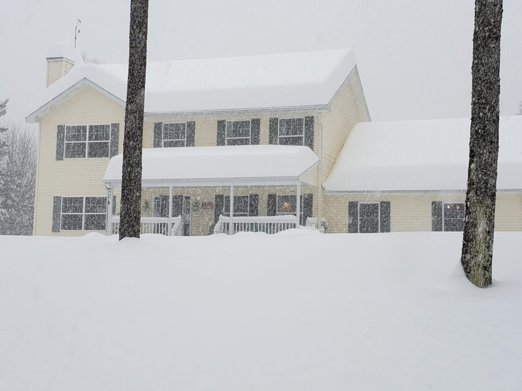
Images from Doug A. Smith of The Storm Report radio affilliate WNUB.  These photos are from Grantham, NH which received 34 inches of the snow!  The dogs don’t seem to mind!

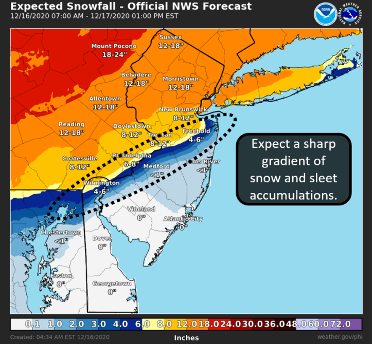
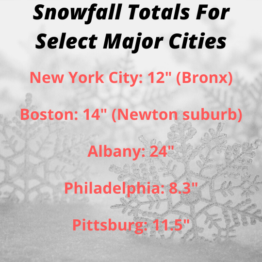
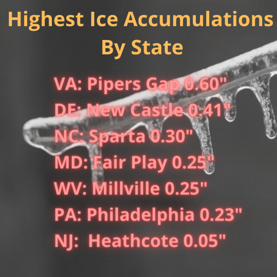
Parts of the Mid-Atlantic, the Northeast and New England were walloped with a winter storm on December 16-17, 2020. Some areas walked away with four feet of snow! Others experienced a mix with some ice accumulation. Here is The Storm Report Recap! 
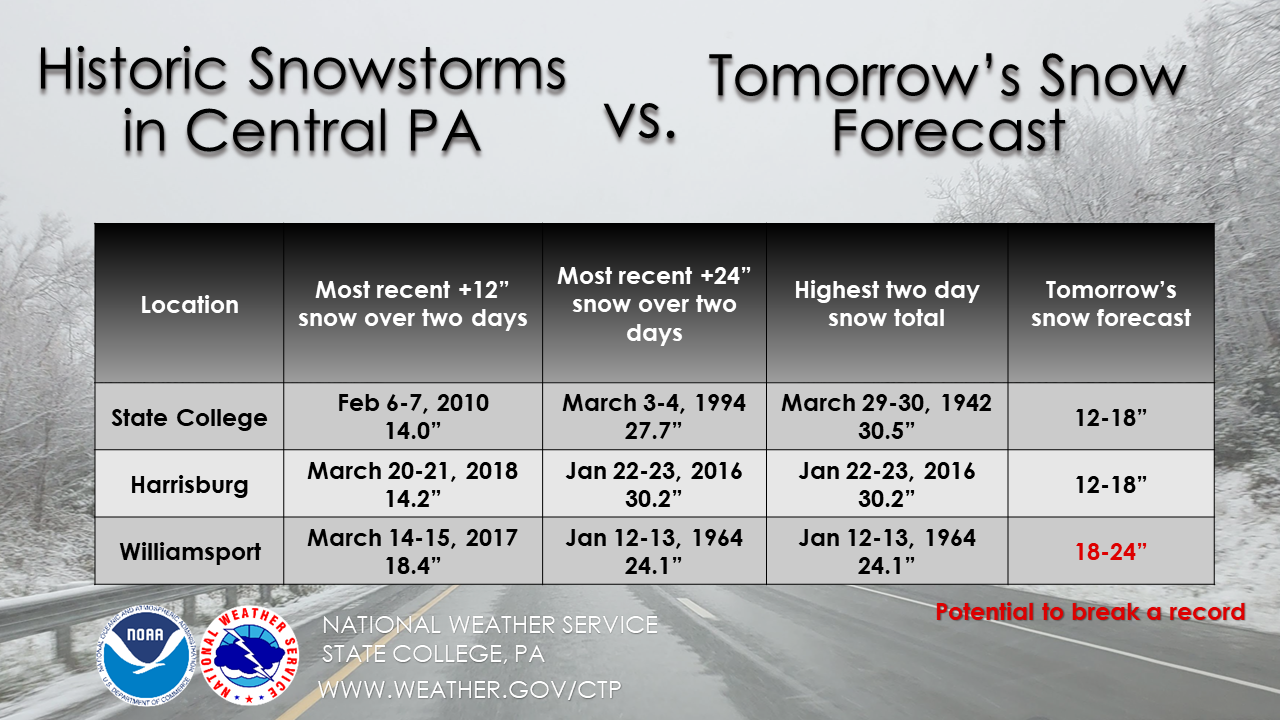
Total snowfall map via the National Weather Service (NWS).


Data from the NWS.

Total Ice Accumulation Map via the NWS.

Data from the NWS.

Record-Setter

As of 7AM this morning, @flyIPT made history – most snow from a single storm on record. Additional snow during the day today could widen the gap even further. #PAwx pic.twitter.com/fi7ghs4DQw

— NWS State College (@NWSStateCollege) December 17, 2020

Thursday's snowfall at Concord was the highest single day snowfall on record and the second biggest snowstorm on record. Records at Concord go back to 1868. #nhwx pic.twitter.com/2nTG7b2saU

— NWS Gray (@NWSGray) December 19, 2020

Tweets from the storm

Snowfall timelapse from Apalachin, NY!

There were two trail cameras in time lapse mode. One appears to have died before the event, the other was buried in the backyard. After some digging I found it. Joy #nywx pic.twitter.com/BV6ku08F4Z

— Ron Murphy (@isixtyfive) December 18, 2020

Ice accretion on Carter Mountain VA!

Some of the thickest #ice (up to an inch) I’ve ever seen in person atop Carter Mountain, overlooking Charlottesville! This is from the #IceStorm on Wednesday.

It reminds me of the ice storm of 1994 and 2003 in the Mid-Ohio Valley (lower elevation). 🧊 ⁦@NWS_BaltWash⁩ pic.twitter.com/DSRkLLaXlc

— Josh Fitzpatrick (@JoshFitzWx) December 18, 2020

Plow truck takes out a mailbox in State College, PA!

That's OK snow plow, I didn't need that mailbox! pic.twitter.com/Fdi62ncq1V

— Jesse Ferrell (@WeatherMatrix) December 17, 2020

Look who knocked on the door in Binghamton, NY!

Pic from friends near Binghamton 😮 pic.twitter.com/H7eg15cEC8

— Andrew Banas (@AndrewWHAM) December 17, 2020

Snow pics from Ludlow, VT!

Here are some great pictures from Ludlow, Vermont, where they got an astounding 44” of snow from Winter Storm Bailey! pic.twitter.com/KEDwkNp2hs

— Jordan Chaplinski (@JordanChappy3) December 17, 2020

People eating dinner as snow falls in NYC!

What a photo.

In Manhattan last night. 📸 by Hiroko Masuikehttps://t.co/trgIm7CPLK pic.twitter.com/Kcxf9Pw0Hj

— Mike Baker (@ByMikeBaker) December 17, 2020

Stories from the storm

Two were killed in a 66 car pile up on Interstate 80 in Clinton County, PA. This occurred during the afternoon of Wednesday, December 16, 2020 on the westbound lane of the interstate. Per the Pennsylvania State Police, one fatality was from the crash. Another was as a result of a medical issue.

Photos show deadly 66-vehicle pile-up in Pennsylvania during snowstorm https://t.co/iyR9zjI7cc pic.twitter.com/ehslSXXSHw

— New York Post (@nypost) December 17, 2020

I 80 multi vehicle fatal crash pic.twitter.com/eQPkGSjSJq

— Troopers Angela Bieber and Mark Reasner (@PSPTroopFPIO) December 17, 2020

A man in Oswego, NY was buried in his car for 10 hours! Per an article in the Associated Press, Kevin Kresen, 58 had driven off the road after passing a snow plow. Per state police, he had been “plowed in by a truck.” From the article, “If he was in there for another hour his body temperature would have gone lower, and I’m convinced he wouldn’t have made it,” State Police Sgt. Jason Cawley, who rescued the man, said in an interview.
With the help of a stranger, parents-to-be Christine and Jay Barker were able to get the hospital in the midst of the winter storm to safely welcome their baby boy into the world. The couple from Roslindale, MA were buried in snow when the Christine realized she was in labor.  She reached out to a community page and stranger came to the rescue.  Per WCVB-TV, “There was one particular guy that ended up coming that we met only because he came, showed up at our house with a mask on, with a shovel, ready to help. Pat Hines, Pat Hines, our knight in shining armor.”

https://youtu.be/yt-i3D2uWI4

Sources

https://www.wearecentralpa.com/news/local-news/police-release-names-of-those-who-died-in-i-80-pileup/

https://pittsburgh.cbslocal.com/2020/12/16/clinton-county-crash-interstate-80/

https://apnews.com/article/new-york-man-buried-car-snow-plow-9c9ac44da5d6059a9fe3bf843ceeee48

https://www.wcvb.com/article/stranger-helps-family-clear-snow-when-mother-goes-into-labor/35020775

Filed Under: Uncategorized

December 16, 2020 By Jennifer Narramore

Historic Snowstorm to Paralyze Parts of the Country

A major snowstorm is expected to impact the Mid-Atlantic and Northeast into New England today into Thursday. Winter storm warnings (pink shading in the map below) stretch from northern North Carolina across the Allegheny Mountains through central Pennsylvania, into southern New England. Snowfall rates of 2-4” per hour are possible at the height of the storm along the spine of the Appalachians. This will create extremely difficult travel as the plows cannot keep up with these types of snowfall rates.

The big cities of the northeast will be hammered with a potpourri of wintry weather and some areas may just plain ole rain, some of it heavy. For the Philadelphia area, for example, snow amounts will be significant north and west of I-95 with the downtown area projected to get 6-8 inches. About 20 miles south of Philadelphia near Medford, NJ, less than an inch of snow is expected.  Southern New Jersey into most of central and southern Delaware, mainly heavy rain is forecast. Coastal Flood Warnings have been hoisted for Atlantic City.  One to two feet of inundation above ground level expected in low-lying areas near shorelines and tidal waterways.


Other major metropolitan areas including New York City, Albany, NY, and Worcester, MA are expected to pick up 12-18” of snow! The Boston, MA, area is forecasted to get 8-12” of snow, and minor coastal flooding is also possible. The Baltimore/Washington DC metro area is slated to get 1-3” of snow before switching over to freezing and then rain. The NWS is forecasting up to a quarter of an inch of ice accretion in Baltimore. From Northern Virginia into West Virginia, over a foot of snow is possible especially from the I-81 corridor and westward, as well as near the Mason-Dixon Line.

The track of this system has shifted more north and west, putting the Pittsburgh area at play for 6-12” of snow and slightly higher totals in Eastern Ohio. Any further shift in the track could affect the outcome of snow totals across the region.

The National Weather Service in State College is calling this a “historic storm” for their region. A large swath of central Pennsylvania is expected to pick up 18-24” of snow! Right now this bullseye appears to be just south and east of the I-99 corridor to near the I-81 corridor. Places like Bedford, Huntingdon, Carlisle, and Wilkes-Barre are expected to see this major snowfall. However, places along I-99, such as Altoona, Tyrone, and State College could also shift into that 18-24” range.


Image via NWS State College.

As you can see by the graphic above, some places such as Williamsport could break their all-time two-day snowfall record from this storm! Are you going to be affected by this storm? We would love to see your photos, tweet them to us @thestormreport or post them to our FaceBook! For the latest forecast from the National Weather Service, click here.

Sources: 

The National Weather Service

Filed Under: blog-3

  • « Previous Page
  • 1
  • 2
  • 3

Real Personalities

When looking to add a trusted source for weather, you want someone who can connect with your audience.   Our meteorologists are also on-air personalities.    The Storm Report team delivers a fresh sound with relatable information to get through the day.  We are your staff meteorologists.

The Storm Report

Follow us on:

Real Passion

We love weather.   No two days are the same.   That fuels our passion.   When weather is serious, you will hear it in our voices.    No text-to-speech computer forecasts.   No robotic audio.   Humans connect with humans and that is what radio is all about.

Real Life

When your community hosts special events, the weather is always a factor.   We weave timely information into your forecast when it comes to fairs, parades, fundraisers or remote broadcasts.    If your weather is sponsored, we are the spokesperson, helping your client earn results.

Copyright © 2026 thestormreport.com