The Storm Report

  • Home
  • Radio Weather
  • Staff
  • Interactive Radar
  • Contact Us

December 5, 2020 By Nick Wilkes

The Vicksburg, MS Tornado – December 5, 1953

On December 5, 1953, the city of Vicksburg, MS was visited by a devastating tornado. The tornado was rated F5 on the Fujita Scale. Tragically 38 people were killed and 270 others were injured.


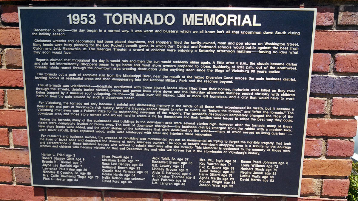
The funnel first formed in Madison County, LA. It moved to the northeast and crossed the Mississippi River. As the tornado crossed the river, it devastated an industrial park. The twister then plowed into downtown Vicksburg. As it moved through downtown, numerous buildings were damaged or destroyed. One of the most tragic events from the tornado occurred downtown. Per Tornadotalk.com: At the Saenger Theatre, Stephanie Mitchell was celebrating her 10th birthday. She was there with her mom, her sister, and a few of her friends. The theatre was directly in the center of the tornado’s path. The ceiling and the wall collapsed, trapping several people under debris. Sadly, five children, all under the age of ten were killed at the theatre.

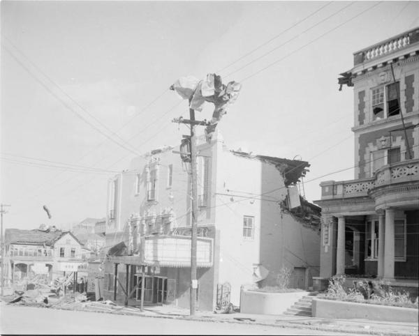
Damage to the Saenger Theatre. Moncrief Photograph Collection, ID #819, Mississippi Department of Archives & History, http://www.mdah.state.ms.us

The twister continued moving northeast, and it hit the Happyland Nursery, sadly two toddlers were killed here. North of downtown, residential areas were decimated resulting in more fatalities. It passed through the western portion of the Vicksburg National Military Park, causing considerable damage. The tornado moved through Waltersville before it dissipated. Here 17 homes and a church were destroyed. https://youtu.be/bOGXFpi1QNM

For more details on this historical event, check out the full summary from our friends at tornadotalk.com.  Tornado Talk also has an archived podcast about this event.  They created 36 episodes of the podcast in 2016-2017.  Here is the story of Vicksburg!

Sources:

Tornado Talk

Filed Under: blog-3

December 4, 2020 By Nick Wilkes

Tornadoes of November 30, 2020

Three tornadoes were confirmed across portions of the Mid-Atlantic on the afternoon of November 30, 2020. Two of these tornadoes occurred in Maryland, and one in Pennsylvania.  The Storm Prediction Center (SPC) had the area in a 5% tornado risk for the afternoon which is considered a “slight risk.”


Day 1 SPC Outlook for November 30, 2020.

The first tornado developed at 2:37 PM EST in Cecil County, MD.  It was rated EF-1 with wind speeds estimated to be 95 mph.  It tracked from about a mile east of Port Deposit, to about 3.4 miles northeast of there, where it dissipated on Twin Lakes Road.  It was 75 yards wide. Numerous trees were knocked down along the path.  The most significant damage occurred along Hopewell Court and Bullet Street.  Several homes were damaged, including one that had significant roof damage. 

Tornado confirmed from yesterday's storms. An EF-1 touched down in Port Deposit, Cecil County yesterday from 2:37pm-2:42pm. It uprooted trees, snapped tree trunks and caused damage to property. #mdwx @wjz pic.twitter.com/F2LZ56iPTl

— Chelsea Ingram (@ChelseaWeather) December 2, 2020

Storm damage from Port Deposit, MD in Cecil County yesterday. Tornado? Possibly! (from Andrew Patrick) @NWS_BaltWash pic.twitter.com/qM4JlIKkAp

— Tony Pann (@TonyPannWBAL) December 1, 2020

The next tornado formed at 3:13 PM EST in Caroline County, MD. This tornado was rated EF-0 with peak winds estimated at 85 mph. It began near the Caroline/Queen Anne’s County border, and tracked east-northeast for 5.3 miles, passing north of Henderson, lifting near Templesville. The damage was confined mostly to trees, however, three small barns were destroyed. A nearby barn had roofing torn off.


Archived radar via RadarScope at 3:16 PM EST showing a definite debris signature in the lower-right panel.

Image via NWS Mount Holly.

The final tornado formed at 3:47 PM EST in Montgomery County, PA. This tornado moved through a shopping center in Montgomeryville. It had peak winds estimated at 70 mph. Several businesses sustained damage to their sidings and roofs. Several wooden picnic tables at a Texas Roadhouse were picked up and thrown about. One of these tables smashed through a window at a nearby sushi restaurant. Six to eight cars in the Texas Roadhouse parking lot were damaged or tossed by the tornado. The twister tracked only half a mile before it lifted in a nearby quarry.


Image via NWS Mount Holly.

So a tornado hit today. About 3 houses away got hit. Think we were on outer fringe. @NBCPhiladelphia @FOX29philly Montgomeryville PA. Right near the mall. pic.twitter.com/tlBuGXRgat

— bob campbell (@BobCampbell77) November 30, 2020

Montgomeryville,PA tornado damage pic.twitter.com/izmYwIWMZW

— Weather Brewed (@WeatherBrewed) December 2, 2020

https://youtu.be/5VbpII1tMYo

The tornadoes in Maryland were the 19th and 20th tornado to occur in the state this year. This is well above the yearly average of five tornadoes. The tornado in Pennsylvania was the 7th tornado to occur this year. This is well below the yearly average of 16 tornadoes.

Sources:

NWS Summary for Cecil County Tornado

Public Information Statement For Caroline County Tornado

Public Information Statement For Montgomery County Tornado

Filed Under: blog-3

December 3, 2020 By Nick Wilkes

Record-Setting Rainfall and Landslides Hit Southeast Alaska


Image via NWS Juneau

On December 1-2, 2020, an “atmospheric river” plowed into southeastern Alaska. An atmospheric river is a channel of deep moisture that flows from the tropics into other areas.  This has led to historic rainfall amounts and flooding across southeastern Alaska.

48 hour rainfall totals from 5-14", wind gusts of 65 mph, 30+ inches of snow, debris flows, flooding, you name it we saw it. The image shows deep moisture surging into the SEAK from the tropics. #AtmosphericRiver #akwx .@KTOOpubmedia .@KHNS_FM .@cbjuneau .@UWCIMSS pic.twitter.com/JkudNcIhar

— NWS Juneau (@NWSJuneau) December 2, 2020

The town of Haines, about 90 miles north of Juneau was the hardest hit. As of the morning of December 2, the town set a record one-day rainfall total (6.36”) and a record two-day rainfall total (8.52”). Flooding and mudslides cut off many roads in town. As of 7:30 am EST, December 3, six people were still unaccounted for after a landslide destroyed four homes on Beach Road. 

Update as of 6pm EST:  Per Alaska’s News Source, four of the people previously missing have been found safe.  There are still two unaccounted for.  “David Simmons and Jenae Larson are still missing, and their homes were located in the landslide area.”

Haines, Alaska, got hit hard with heavy rain (ongoing), floods, mudslides, roads washed out..everything closed including airport and medical clinic..CG Medivac had to land in town this morning..Images: Young Rd, Spruce Grove, Airport pic.twitter.com/khvKeBidQ4

— akmk (@akmk) December 2, 2020


In Juneau, over 5” of rain fell, setting a new record. This rain led to flooding throughout the city. Strong winds as high as 60-65 mph also battered the Alaskan town, knocking down numerous trees. A tree fell onto a house in the Switzer Village neighborhood.

Jordan Square area around #Juneau’s Jordan Creek not looking good this Wednesday morning at 7:10 AM. #akwx @cbjuneau @NWSJuneau #flood #atmosphericriver chiropractic care cancelled this morning. 🙁 pic.twitter.com/gSEn7oV7Se

— Westbrook Adkins (@westbrookadkins) December 2, 2020

Sources:

NWS Juneau

Alaska Department of Public Safety

https://www.alaskasnewssource.com/2020/12/02/roads-cave-in-haines-as-heavy-rains-impact-southeast-alaska/

https://www.ktoo.org/2020/12/02/record-breaking-rainfall-leaves-muddy-mess-across-southeast-alaska/

Filed Under: blog-3

November 29, 2020 By Jennifer Narramore

The Beaver Moon


November’s Full Beaver Moon will rise on Monday, November 30, 2020 and this year will be joined with a penumbral lunar eclipse.   Per timeanddate.com, “A penumbral lunar eclipse takes place when the Moon moves through the faint, outer part of Earth’s shadow, the penumbra.”  This year, approximately 82% of the Moon’s face will turn slightly darker during the maximum phase of the eclipse.  Per NASA, the greatest eclipse will be at 942 Universal Time on Nov 30.


So, why is the November full Moon traditionally called the Beaver Moon?  Per the Old Farmer’s Almanac, this is the time of year when the industrious rodents who have been working to store food for the winter ahead, begin to shelter.  They put on their hard hats and complete the development of their winter dams.  The November Full Moon is also called the Frost Moon or the Freezing Moon.  This is the last full moon before the winter solstice.

Sources:

https://www.timeanddate.com/eclipse/penumbral-lunar-eclipse.html

https://eclipse.gsfc.nasa.gov/lunar.html

https://www.almanac.com/content/full-moon-november

Filed Under: blog-3

November 25, 2020 By Nick Wilkes

The Great Appalachian Storm of 1950


Map of snowfall totals between November 22 and 30, 1950, along with corresponding Regional Snowfall Index information. (NCDC).

During Thanksgiving weekend in 1950, a long-lasting winter storm meandered its way across the Ohio Valley and Northeast. The storm developed on November 24 and moved off the coast of New England on November 29.  It ranks as the worst snowstorm to affect the area.

This major snowstorm unfolded across the Ohio Valley, with a large area picking up over 30” of snow over a 3-day period. A whopping 62” of snow fell on Coburn Creek, WV. Pittsburgh, PA received 27.4” of snow, which to this day is the biggest snowstorm to affect the city!


Photo of the snow in Cleveland (NCDC).

Hurricane-force winds battered the coastal regions of the northeast and New England. These winds caused extensive tree damage and power outages. There was a 94 mph wind gust in New York City and a 108 mph wind gust in Newark, NJ. Even higher wind gusts occurred in the mountains. Bear Mountain, about 40 miles north of New York City, had 140 mph wind gusts, and there was a 160 mph wind gust at Mount Washington, NH.

Flooding affected several rivers and coastal regions. The Ohio River crested at 28.5 feet, four feet above flood level, in Downtown Pittsburgh. In Cincinnati, OH, it reached 56 feet, which is also four feet above flood stage. The Little Juniata River flooded most of downtown Tyrone, PA. Coastal flooding affected New Jersey, New York, and Connecticut. Runways were left underwater at LaGuardia Airport.

A major ice storm crippled Altoona, PA, beginning on November 24, ending the next morning. As much as four inches of ice accretion caused severe tree and power line destruction in the city. Even high tension, metal, towers were brought down. The city was without power for up to 3 weeks, and most roads were blocked under the fallen trees and wires.

Photograph of downed trees and power poles in Altoona, via the Altoona Mirror from newspaperarchives.com.

The storm system also brought frigid conditions to the southeast. Temperatures fell to 22°F in Pensacola, FL, 5°F in Birmingham, AL, and 3°F in Atlanta, GA. This record cold led to widespread crop damage, particularly in Georgia and South Carolina.

Sources:

NWS Jackson, KY
NCEI
WPXI.com

Filed Under: blog-3

  • « Previous Page
  • 1
  • …
  • 3
  • 4
  • 5
  • 6
  • Next Page »

Real Personalities

When looking to add a trusted source for weather, you want someone who can connect with your audience.   Our meteorologists are also on-air personalities.    The Storm Report team delivers a fresh sound with relatable information to get through the day.  We are your staff meteorologists.

The Storm Report

Follow us on:

Real Passion

We love weather.   No two days are the same.   That fuels our passion.   When weather is serious, you will hear it in our voices.    No text-to-speech computer forecasts.   No robotic audio.   Humans connect with humans and that is what radio is all about.

Real Life

When your community hosts special events, the weather is always a factor.   We weave timely information into your forecast when it comes to fairs, parades, fundraisers or remote broadcasts.    If your weather is sponsored, we are the spokesperson, helping your client earn results.

Copyright © 2026 thestormreport.com