The Storm Report

  • Home
  • Radio Weather
  • Staff
  • Interactive Radar
  • Contact Us

December 16, 2020 By Jennifer Narramore

Historic Snowstorm to Paralyze Parts of the Country

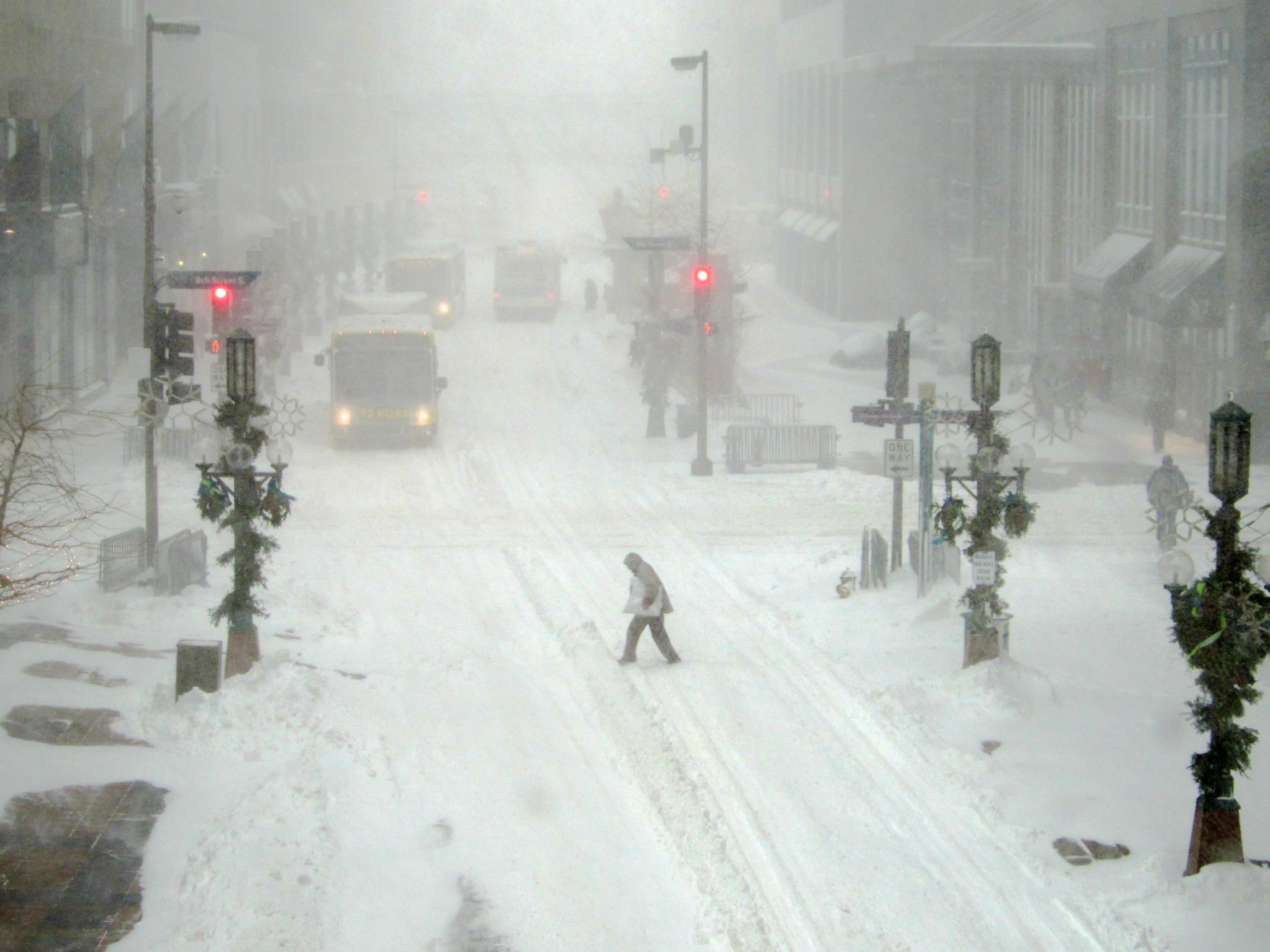
A major snowstorm is expected to impact the Mid-Atlantic and Northeast into New England today into Thursday. Winter storm warnings (pink shading in the map below) stretch from northern North Carolina across the Allegheny Mountains through central Pennsylvania, into southern New England. Snowfall rates of 2-4” per hour are possible at the height of the storm along the spine of the Appalachians. This will create extremely difficult travel as the plows cannot keep up with these types of snowfall rates.

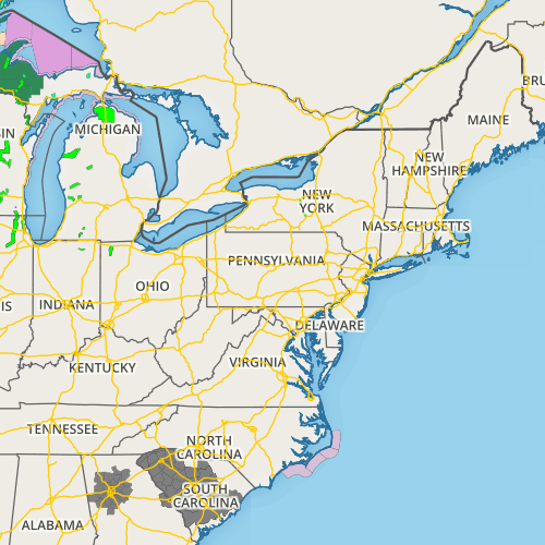
The big cities of the northeast will be hammered with a potpourri of wintry weather and some areas may just plain ole rain, some of it heavy. For the Philadelphia area, for example, snow amounts will be significant north and west of I-95 with the downtown area projected to get 6-8 inches. About 20 miles south of Philadelphia near Medford, NJ, less than an inch of snow is expected.  Southern New Jersey into most of central and southern Delaware, mainly heavy rain is forecast. Coastal Flood Warnings have been hoisted for Atlantic City.  One to two feet of inundation above ground level expected in low-lying areas near shorelines and tidal waterways.


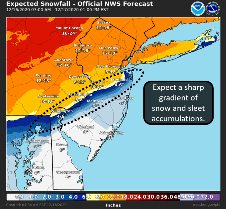
Other major metropolitan areas including New York City, Albany, NY, and Worcester, MA are expected to pick up 12-18” of snow! The Boston, MA, area is forecasted to get 8-12” of snow, and minor coastal flooding is also possible. The Baltimore/Washington DC metro area is slated to get 1-3” of snow before switching over to freezing and then rain. The NWS is forecasting up to a quarter of an inch of ice accretion in Baltimore. From Northern Virginia into West Virginia, over a foot of snow is possible especially from the I-81 corridor and westward, as well as near the Mason-Dixon Line.

The track of this system has shifted more north and west, putting the Pittsburgh area at play for 6-12” of snow and slightly higher totals in Eastern Ohio. Any further shift in the track could affect the outcome of snow totals across the region.

The National Weather Service in State College is calling this a “historic storm” for their region. A large swath of central Pennsylvania is expected to pick up 18-24” of snow! Right now this bullseye appears to be just south and east of the I-99 corridor to near the I-81 corridor. Places like Bedford, Huntingdon, Carlisle, and Wilkes-Barre are expected to see this major snowfall. However, places along I-99, such as Altoona, Tyrone, and State College could also shift into that 18-24” range.


Image via NWS State College.

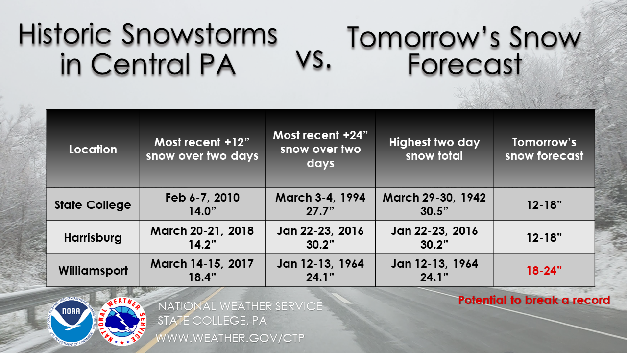
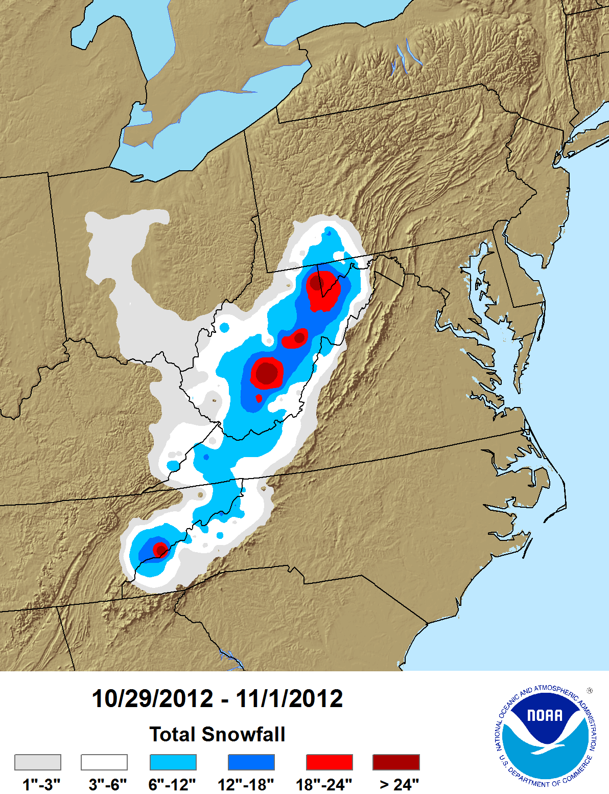
As you can see by the graphic above, some places such as Williamsport could break their all-time two-day snowfall record from this storm! Are you going to be affected by this storm? We would love to see your photos, tweet them to us @thestormreport or post them to our FaceBook! For the latest forecast from the National Weather Service, click here.

Sources: 

The National Weather Service

Filed Under: blog-3

December 13, 2020 By Nick Wilkes

Meteo Monday-Blizzards

In this week’s Meteo Monday, we are taking a look at blizzards! Blizzards are very impactful winter storms, but there are a lot of misconceptions as to what a blizzard actually is. Many people think that any big snowstorm is a blizzard. This is not true. To be a blizzard, a snowstorm has to have blowing snow and reduced visibility. You can have a blizzard with just one to two inches of snowfall accumulation.


A photo taken during a blizzard in Minneapolis, MN, on December 12, 2012. Photo via Wikimedia Commons.

Per the American Meteorological Society (AMS) for a snowstorm to be classified as a blizzard it must reach each of these criteria for three consecutive hours or longer: 

  • Sustained wind or frequent gusts of at least 35 mph or higher 
  • Falling and/or blowing snow that reduces visibility to less than a quarter of a mile (0.25 miles). 

Past criteria included low temperatures of 20℉ or colder, but this is no longer required.

There is also what is known as a ground blizzard. A ground blizzard is caused when an Artic cold front accompanied by strong winds moves across an area that has freshly fallen snow. The wind whips the snow up creating a whiteout. One of the worst blizzards in US history was a ground blizzard on January 12, 1888. Per the NWS: “One of the most infamous ground blizzards was the Children’s Blizzard of 1888, which killed an estimated 235 people in the Great Plains. This ground blizzard was extremely dangerous because it was preceded by unseasonably warm air, which caused people to let their guard down. Many people ventured outside without proper winter clothing, but the relatively warm weather did not last long.”


Some notable blizzards include; 

  • The 1950 Great Appalachian Storm: You can read our retrospective here. 
  • The “Great Blizzard of 1978”:  Also called the “Cleveland Superbomb”, this blizzard produced wind gusts over 100 mph! 
  • The 1993 “Storm of the Century”: This storm brought heavy snow and blizzard conditions from Alabama northward into New England.
  • The Blizzard of 1996: Paralyzed parts of the Eastern U.S. with over four feet of snow.
  • “Snowmageddon” in 2010:  Massive snow and blizzard conditions occurred across parts of the Mid-Atlantic. Dulles Airport had its greatest snow on record, 32.4 inches.

Ironically, there has even been a hurricane-induced blizzard! On October 30th, 2012, the morning after Sandy made landfall in NJ, a blizzard occurred from the mountains of western North Carolina, through West Virginia, into Southwestern PA. Tropical storm to hurricane-force winds and several feet of snow produced widespread damage across this area.


Map from NCDC showing the snowfall totals produced by Hurricane Sandy.

Sources: 

https://en.wikipedia.org/wiki/Blizzard

https://glossary.ametsoc.org/wiki/Blizzard

https://www.weather.gov/safety/winter-ground-blizzard

Filed Under: blog-3

December 11, 2020 By Nick Wilkes

The Geminid Meteor Shower!

Over 100 meteors are recorded in this composite image taken during the peak of the Geminid meteor shower in 2014. 
Credit: NASA/MSFC/Danielle Moser, NASA's Meteoroid Environment Office)
Over 100 meteors are recorded in this composite image taken during the peak of the Geminid meteor shower in 2014.
Credit: NASA/MSFC/Danielle Moser, NASA’s Meteoroid Environment Office)

The Geminid meteor shower has been active! It began December 1, and is expected to end around December 22. The peak of the shower will be on the night of December 13 into the morning hours of the 14th. The Geminids are considered by the American Meteor Society (AMS), the most dependable and vibrant meteor showers of the year. The meteors are often bright and intensely colored. During its peak, up to 120 meteors are visible per hour!

The Geminid meteor shower gets its name as their apparent radiant (point in the sky they appear to come from) is in the constellation Gemini. NASA denotes: “The constellation for which a meteor shower is named only serves to aid viewers in determining which shower they are viewing on a given night. The constellation is not the source of the meteors. Also, you should not look only to the constellation of Gemini to view the Geminids — they are visible throughout the night sky.” 

What is a meteor shower and what makes the Geminids different from other meteor showers? Per the AMS: “Most meteor showers have their origins with comets. Each time a comet swings by the sun, it produces copious amounts of meteoroid sized particles which will eventually spread out along the entire orbit of the comet to form a meteoroid “stream.” If the Earth’s orbit and the comet’s orbit intersect at some point, then the Earth will pass through this stream for a few days at roughly the same time each year, encountering a meteor shower.” 

The Geminids are NOT caused by a comet. They are in association with the 3200 Phaethon asteroid, which orbits the sun closer than any other asteroid. This asteroid gets its name from Phaëthon the son of the Greek god of the sun, Helos.  The Geminids first appeared in the mid 1800s.


Graphic on where to look to see the meteor shower (NASA).

How can you view the meteor shower? According to NASA: “The Geminids are best viewed during the night and predawn hours and are visible across the globe due to a nearly 24-hour broad maximum. This shower is considered one of the best opportunities for young viewers since this shower starts around 9 or 10 p.m”  Here are a few tips on how you can best observe the Geminids: 

  • Find an area well away from city or street lights.
  • Be prepared for cold temperatures.  Bring a sleeping bag or a blanket.
  • Lie flat on your back with your feet facing the south and look up. After about 30 minutes your eyes should be adjusted to the dark. 
  • Be patient! You may not see anything right away.  Luckily the meteor shower will be going through the night. 

Sources: 

https://www.amsmeteors.org/2020/12/viewing-the-geminid-meteor-shower-in-2020/

https://www.amsmeteors.org/meteor-showers/meteor-faq/#5

https://solarsystem.nasa.gov/asteroids-comets-and-meteors/meteors-and-meteorites/geminids/in-depth/

https://solarsystem.nasa.gov/resources/2567/whats-up-december-2020-video/

Filed Under: blog-3

December 9, 2020 By Nick Wilkes

Weather Themed Christmas Presents!

It’s that time of year again!  We need to get our Christmas lists to Santa!  If you are a weather geek like me, you are probably hoping that Old Saint Nick will bring you something with a tornado on it!  I did a search on Amazon for some cool weather-related gifts.  Here are some of the things I found. Maybe there is something here you can add to your list and if you have been nice, Santa will make sure it lands under your tree Christmas morning!

(Note: These are not affiliate links. We don’t make any money if you click on them.  We just think these are cool gift ideas!  Prices may have changed from the time we did the searches).

Under $20

Tedco – Pet Tornado – Shake and Watch – Realistic Tornado Kit – ($9.56)

It’s like a Pet Rock, but it’s a tornado! You can take your Pet Tornado anywhere you go!

SmartLab Toys You-Track-It Weather Lab – ($12)

This weather lab is great for the youngsters that are just starting to get interested in weather!

Trust Me I’m A Meteorologist Coffee Mug – ($12.95)

Let’s be honest, we all want this coffee mug.

Storm Chaser Shirt Funny Storm Hunter Quote Weather Gift – ($18.85)

Know someone who is always talking about tornadoes? Well then this is a perfect gift for them!

$20 to $50

CAVALLO MERCANTILE Storm Glass Weather Predictor with Dark Wood Base – Barometer Bottle – Weather Station – Unique Gift – ($23.99)

Per the Amazon Listing: “As the weather changes, the crystals inside the storm glass weather station change to reflect the forecast.”  This would look great on the desks of any meteorologist.

FosPower Emergency Solar Hand Crank Portable Radio, NOAA Weather Radio for Household and Outdoor Emergency with AM/FM, LED Flashlight, Reading Lamp, 2000mAh Power Bank USB Charger and SOS Alarm – ($25.49)

If you know someone that lives in an area that deals with dangerous weather frequently, this is a perfect gift for them. If the storm takes out the power, this Solar Powered/Hand Crank radio not only connects to the AM/FM Stations, it has a NOAA Weather radio built in. It also has a built in flashlight and a built in phone charger!

AcuRite 00795A2 Galileo Thermometer with Glass Globe Barometer, Barometer Set – (34.38)

Want to look at the weather the same way Galileo Galilei did in 1593? Well here’s your solution. Plus it just looks cool!

SensoryMoon Pet Tornado Twister Lamp – Mini Water Vortex Maker Machine in 14” Color Changing Tube is Best Plug in LED Mood Night Light, Extreme Weather Related Gift, and Science Lab Toy for Kids – ($44.95)

This LED color changing nightlight also doubles as a tornado in the bottle! You can have a tornado spinning on your nightstand all night long as you dream about chasing storms!

$50 to $100

AcuRite 00634A3 Wireless Weather Station with Wind Sensor, Black – ($67.99)

Looking for a weather station, but you don’t need it to hook up to your phone and you’re on budget? This AcuRite Weather Station will get the job done!

Over $100

Ambient Weather WS-2902C WiFi Smart Weather Station: Price – ($169.99)

This weather station is a great pick for anyone. The author of this list, uses this as his personal weather station. It seems to provide pretty accurate numbers, and it quickly hooks up to the Ambient Weather App where you can track the conditions in your own backyard no matter where you are.

Filed Under: blog-3

December 6, 2020 By Steve Hamilton

Welcome To A La Niña Winter!

Just about everyone has heard of El Niño.  But what about its opposite, La Niña?  What is this climatological phenomenon?  How does it work?  And, what effect will it have on our weather over the next few months?

La Niña is just one phase of the “El Niño Southern Oscillation”, or “ENSO”, which is a pattern of air pressure and ocean currents across the Central Pacific Ocean. The opposite of La Niña is El Niño. In between is what we call the “neutral” phase. In between those are the “transitional” phases. El Niño is the warm phase of this circulation, with relatively warm water piling up in the Eastern Pacific, while La Niña is the cool phase.

ENSO doesn’t just affect the Eastern Pacific though. It’s one of the most influential circulations in North American weather.

The National Oceanic And Atmospheric Administration (NOAA), along with other worldwide scientific agencies, monitor ocean temperatures and air pressure constantly. They do this in order to determine which phase of ENSO we’re in, and roughly how long it is expected to stay in that phase, or change back to the opposite phase.

This back and forth pattern has been known for centuries. Thanks to modern technology, including satellite data and automated ocean buoys, it can be tracked and predicted more accurately than ever.

The oscillation isn’t really predictable in the long term. We may see a La Niña go from neutral, then right back to La Niña, or stay in an El Niño phase for several seasons. Or, it may stay neutral for a while. Or, we might see a “mild” or “super” phase.

According to recent data from the Climate Prediction Center (CPC), La Niña is in full swing, with good chances of it staying in place through March 2021. Here’s a look at what this might portend for the average weather this winter. These are the latest climate maps for the next month, from the CPC.


1monthtemp

1monthprecip

Here’s a quick look at how ENSO works. During a La Niña, we get colder ocean water piling up in the Eastern Pacific. This will tend to cause an east-to-west flow of air along the Equator. This is because cold air is more dense, with higher surface pressure, and will tend to flow toward lower pressure. The movement of air also contributes to the movement of the ocean water below, and vice-versa, in a feedback loop. 

With La Niña, wind blowing from east to west will move surface water from the Eastern Pacific. So, colder water from below will rise up to replace it, causing a loop which continues until the pattern is disrupted.


The opposite holds true for El Niño, with warmer water in the Eastern Pacific, and a west-to-east atmospheric flow. The warmer water near western North America will tend to cause lower air pressure, bringing more favorable conditions for formation and precipitation for the southwestern and southern parts of the country. With La Niña, we get cooler air and water, which suppresses cloud development, and thus, less rain over those regions.

Things get tricky with these changes, because different effects will be felt over different regions of the USA. While the western and southern states are often more dry and warm during a La Niña, the northern and eastern regions may get an increase in precipitation and a decrease in temperature. During El Niño, it may be the opposite.

Keep in mind, when we talk about warmer or colder, and wetter and drier, that refers to “seasonal averages”, since each phase of ENSO usually lasts for several months. So, blaming ENSO for any one short-term weather event is usually not a good idea. 

Also keep in mind that ENSO is just one of many regularly-occurring ocean/atmosphere circulations around the world, which affect our weather in the United States. But, ENSO tends to get the most attention, since the impacts are usually more evident over three-month periods.

That brings us to the current situation. The CPC started seeing indications last summer of an approaching La Niña phase. Now that sea surface temperatures and other data have confirmed the things, a “La Niña Advisory” has been issued by the CPC.

From their powerpoint presentation of November 16, 2020: “La Niña conditions are present. Equatorial sea surface temperatures are below average from the west-central to the eastern Pacific Ocean. The tropical atmospheric circulation is consistent with La Niña. La Niña is likely to continue through the Northern Hemisphere winter, 2020-2021.”

They indicate a 95% chance that La Niña will be present from January through March, and a 65% chance of it continuing into spring of next year. NOAA and other scientific agencies not only measure sea-surface temperature, but also at various depths. Likewise, while surface winds are measured, wind direction and speed are also measured higher up, to determine the strength of the ENSO phase. 

With the onset of a La Niña winter, generally speaking, we can expect a warmer, drier weather pattern for the western and southern states, and somewhat cooler and wetter conditions for the northern and eastern areas.

The CPC provides a seasonal outlook, and also a month-by-month prediction of weather trends, largely based on the ENSO circulation. But keep in mind that other atmospheric trends come into play. In other words, La Niña won’t control our weather completely.

We mentioned before that while ENSO definitely has an impact on regional weather across the country, it’s measured or observed, then averaged-out on a seasonal basis, or over the duration of the ENSO phase. That means, short-term weather isn’t predicted simply based on whether we’re in a La Niña, Neutral or El Niño.

In fact, over the years, trends have been observed that are exactly opposite what we’d expect from a certain ENSO phase, usually due to other contributing factors well away from North America. All of the various circulations are interwoven, or “teleconnected”. That is to say, predicting an oncoming ENSO phase is usually easier than predicting the daily weather for any given city.

To sum it all up, heading into a La Niña winter, we should, on average, see more precipitation and cooler weather for the northern and eastern states, and warmer, drier weather for the south and west. You can track all of this by looking up The Climate Prediction Center online. Their site is constantly updated with seasonal rainfall and temperature forecasts.

Sources:

Climate Prediction Center (One-Month Outlooks & Winter Outlook and Graphics) La Nina specifications, La Nina Advisory and associated data La Nina/El Nino Status 1 La Nina/El Nino Status 2

Filed Under: blog-3

  • « Previous Page
  • 1
  • 2
  • 3
  • 4
  • 5
  • 6
  • Next Page »

Real Personalities

When looking to add a trusted source for weather, you want someone who can connect with your audience.   Our meteorologists are also on-air personalities.    The Storm Report team delivers a fresh sound with relatable information to get through the day.  We are your staff meteorologists.

The Storm Report

Follow us on:

Real Passion

We love weather.   No two days are the same.   That fuels our passion.   When weather is serious, you will hear it in our voices.    No text-to-speech computer forecasts.   No robotic audio.   Humans connect with humans and that is what radio is all about.

Real Life

When your community hosts special events, the weather is always a factor.   We weave timely information into your forecast when it comes to fairs, parades, fundraisers or remote broadcasts.    If your weather is sponsored, we are the spokesperson, helping your client earn results.

Copyright © 2026 thestormreport.com