The Storm Report

  • Home
  • Radio Weather
  • Staff
  • Interactive Radar
  • Contact Us

December 3, 2020 By Nick Wilkes

Record-Setting Rainfall and Landslides Hit Southeast Alaska


Image via NWS Juneau

On December 1-2, 2020, an “atmospheric river” plowed into southeastern Alaska. An atmospheric river is a channel of deep moisture that flows from the tropics into other areas.  This has led to historic rainfall amounts and flooding across southeastern Alaska.

48 hour rainfall totals from 5-14", wind gusts of 65 mph, 30+ inches of snow, debris flows, flooding, you name it we saw it. The image shows deep moisture surging into the SEAK from the tropics. #AtmosphericRiver #akwx .@KTOOpubmedia .@KHNS_FM .@cbjuneau .@UWCIMSS pic.twitter.com/JkudNcIhar

— NWS Juneau (@NWSJuneau) December 2, 2020

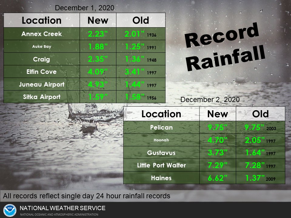
The town of Haines, about 90 miles north of Juneau was the hardest hit. As of the morning of December 2, the town set a record one-day rainfall total (6.36”) and a record two-day rainfall total (8.52”). Flooding and mudslides cut off many roads in town. As of 7:30 am EST, December 3, six people were still unaccounted for after a landslide destroyed four homes on Beach Road. 

Update as of 6pm EST:  Per Alaska’s News Source, four of the people previously missing have been found safe.  There are still two unaccounted for.  “David Simmons and Jenae Larson are still missing, and their homes were located in the landslide area.”

Haines, Alaska, got hit hard with heavy rain (ongoing), floods, mudslides, roads washed out..everything closed including airport and medical clinic..CG Medivac had to land in town this morning..Images: Young Rd, Spruce Grove, Airport pic.twitter.com/khvKeBidQ4

— akmk (@akmk) December 2, 2020


In Juneau, over 5” of rain fell, setting a new record. This rain led to flooding throughout the city. Strong winds as high as 60-65 mph also battered the Alaskan town, knocking down numerous trees. A tree fell onto a house in the Switzer Village neighborhood.

Jordan Square area around #Juneau’s Jordan Creek not looking good this Wednesday morning at 7:10 AM. #akwx @cbjuneau @NWSJuneau #flood #atmosphericriver chiropractic care cancelled this morning. 🙁 pic.twitter.com/gSEn7oV7Se

— Westbrook Adkins (@westbrookadkins) December 2, 2020

Sources:

NWS Juneau

Alaska Department of Public Safety

https://www.alaskasnewssource.com/2020/12/02/roads-cave-in-haines-as-heavy-rains-impact-southeast-alaska/

https://www.ktoo.org/2020/12/02/record-breaking-rainfall-leaves-muddy-mess-across-southeast-alaska/

Filed Under: blog-3

November 29, 2020 By Jennifer Narramore

The Beaver Moon


November’s Full Beaver Moon will rise on Monday, November 30, 2020 and this year will be joined with a penumbral lunar eclipse.   Per timeanddate.com, “A penumbral lunar eclipse takes place when the Moon moves through the faint, outer part of Earth’s shadow, the penumbra.”  This year, approximately 82% of the Moon’s face will turn slightly darker during the maximum phase of the eclipse.  Per NASA, the greatest eclipse will be at 942 Universal Time on Nov 30.


So, why is the November full Moon traditionally called the Beaver Moon?  Per the Old Farmer’s Almanac, this is the time of year when the industrious rodents who have been working to store food for the winter ahead, begin to shelter.  They put on their hard hats and complete the development of their winter dams.  The November Full Moon is also called the Frost Moon or the Freezing Moon.  This is the last full moon before the winter solstice.

Sources:

https://www.timeanddate.com/eclipse/penumbral-lunar-eclipse.html

https://eclipse.gsfc.nasa.gov/lunar.html

https://www.almanac.com/content/full-moon-november

Filed Under: blog-3

November 25, 2020 By Nick Wilkes

The Great Appalachian Storm of 1950


Map of snowfall totals between November 22 and 30, 1950, along with corresponding Regional Snowfall Index information. (NCDC).

During Thanksgiving weekend in 1950, a long-lasting winter storm meandered its way across the Ohio Valley and Northeast. The storm developed on November 24 and moved off the coast of New England on November 29.  It ranks as the worst snowstorm to affect the area.

This major snowstorm unfolded across the Ohio Valley, with a large area picking up over 30” of snow over a 3-day period. A whopping 62” of snow fell on Coburn Creek, WV. Pittsburgh, PA received 27.4” of snow, which to this day is the biggest snowstorm to affect the city!


Photo of the snow in Cleveland (NCDC).

Hurricane-force winds battered the coastal regions of the northeast and New England. These winds caused extensive tree damage and power outages. There was a 94 mph wind gust in New York City and a 108 mph wind gust in Newark, NJ. Even higher wind gusts occurred in the mountains. Bear Mountain, about 40 miles north of New York City, had 140 mph wind gusts, and there was a 160 mph wind gust at Mount Washington, NH.

Flooding affected several rivers and coastal regions. The Ohio River crested at 28.5 feet, four feet above flood level, in Downtown Pittsburgh. In Cincinnati, OH, it reached 56 feet, which is also four feet above flood stage. The Little Juniata River flooded most of downtown Tyrone, PA. Coastal flooding affected New Jersey, New York, and Connecticut. Runways were left underwater at LaGuardia Airport.

A major ice storm crippled Altoona, PA, beginning on November 24, ending the next morning. As much as four inches of ice accretion caused severe tree and power line destruction in the city. Even high tension, metal, towers were brought down. The city was without power for up to 3 weeks, and most roads were blocked under the fallen trees and wires.

Photograph of downed trees and power poles in Altoona, via the Altoona Mirror from newspaperarchives.com.

The storm system also brought frigid conditions to the southeast. Temperatures fell to 22°F in Pensacola, FL, 5°F in Birmingham, AL, and 3°F in Atlanta, GA. This record cold led to widespread crop damage, particularly in Georgia and South Carolina.

Sources:

NWS Jackson, KY
NCEI
WPXI.com

Filed Under: blog-3

November 21, 2020 By Dan Holiday

The Storm Report Radio Network Surpasses 300 Affiliate Stations

In the midst of a pandemic, more radio stations are operating remotely, and that has allowed the weather forecast service from The Storm Report to flourish.    More than 300 signals from coast to coast and online now utilize the weather team’s audio updates which also include breaking information about rapidly changing weather. 

“We began in 2005 as a daily feature on radio and have since diversified to provide 24/7 timely information.   Listeners greatly rely on radio as a trusted source for weather in their local communities, said Dan Holiday, president of The Storm Report.   “Our staff meteorologists wrap themselves inside the culture of each community.    We mention local events and business happenings and brand ourselves as the station meteorologists.” 

Radio companies in Denver, New Orleans, Salt Lake City, Baton Rouge and Springfield, Missouri, are some of the latest additions to The Storm Report roster.   To learn more, visit www.thestormreport.com or call (800) 967-0130.

Filed Under: blog-3

November 11, 2020 By Dan Holiday

Kansas Association of Broadcasters Convention Features Seminar on Improving Severe Weather Coverage

For the first time in its history, the annual Kansas Association of Broadcasters convention was conducted virtually on October 19-22nd, 2020.   While members did not converge in Wichita this year, they did join seminars online from across the sunflower state.  

The Storm Report Radio Network conducted an interactive tutorial on how broadcasters could improve coverage of severe weather.    Panelists included KMBC-TV Chief Meteorologist Bryan Busby, Dr. Laura Myers, a Research Scientist with the Center for Advanced Public Safety at the University of Alabama, Chad Omitt who is the Warning Coordination Meteorologist at the National Weather Service in Topeka and Jennifer Narramore, Radio Meteorologist at The Storm Report.   The panel was moderated by The Storm Report’s co-founder, Dan Holiday.  

Dr. Myers discussed new research that indicates how residents most commonly receive severe weather information.   Myers also said they typically look for two sources to insure they can trust the weather warning that when issued for their area.

Busby told broadcasters to be natural on-air and avoid over dramatizing threatening weather to viewers.    He told future TV meteorologists that while weather enthusiasts may get excited about a tornado, the audience is often ridden with anxiety.   Therefore, Busby said it is important to be factual and empathetic.  

Omitt reminded broadcasters to emphasize the dangers during winter weather which often claims more lives than spring severe storms.    Narramore advised radio broadcasters to paint a picture of the situation on the air so the audience could visualize what is happening and react appropriately.   

The seminar is available for online viewing through December 31, 2020, for members who have purchased a convention pass at kab.net.  

Filed Under: News

  • « Previous Page
  • 1
  • …
  • 5
  • 6
  • 7
  • 8
  • Next Page »

Real Personalities

When looking to add a trusted source for weather, you want someone who can connect with your audience.   Our meteorologists are also on-air personalities.    The Storm Report team delivers a fresh sound with relatable information to get through the day.  We are your staff meteorologists.

The Storm Report

Follow us on:

Real Passion

We love weather.   No two days are the same.   That fuels our passion.   When weather is serious, you will hear it in our voices.    No text-to-speech computer forecasts.   No robotic audio.   Humans connect with humans and that is what radio is all about.

Real Life

When your community hosts special events, the weather is always a factor.   We weave timely information into your forecast when it comes to fairs, parades, fundraisers or remote broadcasts.    If your weather is sponsored, we are the spokesperson, helping your client earn results.

Copyright © 2026 thestormreport.com