The Storm Report

  • Home
  • Radio Weather
  • Staff
  • Interactive Radar
  • Contact Us

January 18, 2021 By Nick Wilkes

Meteo Monday – Winter Precipitation Types

It is that time of the week again, Meteo Monday! In this week’s edition, we are going to take a look at winter precipitation types. Have you ever wondered what the difference is between sleet and freezing rain? Have you ever stepped outside and observed what look like Dippin’ Dots ice cream on the ground? Different layers of warm and cold air between the clouds determine the type of precipitation that reaches the ground.


Precipitation type formation via National Weather Service.

Snow

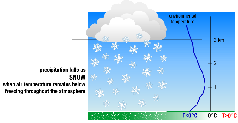
Most precipitation that forms in winter starts as snow because the top layer of the storm is usually cold enough to create snowflakes. Snowflakes are collections of ice crystals that cling to each other. If the air temperature remains below freezing to the ground, you will get snow.


Snowfall graphic via National Weather Service.

The author’s dog playing in the snow on December 16, 2020.

Sleet

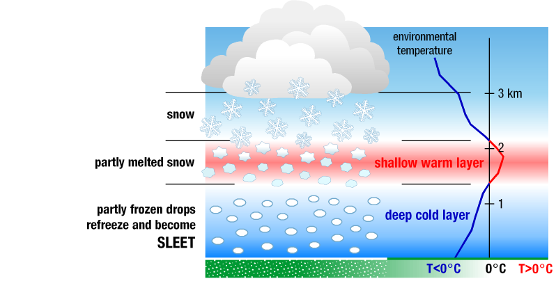
Sleet forms when you have snow that falls through a shallow warm layer of the atmosphere. As it falls through this layer, it starts to melt. It then falls through a cold layer at the surface, where it refreezes. Sleet is the tiny ice pellets that fall and bounce upon impact. Some people think that sleet is the same as hail. However, this is not true. They may look similar, but sleet is caused by snow melting and refreezing. Hail is generated in a thunderstorm.


Sleet graphic via National Weather Service.

Sleet next to a penny for scale via Runningonbrains from Wikipedia.

Graupel

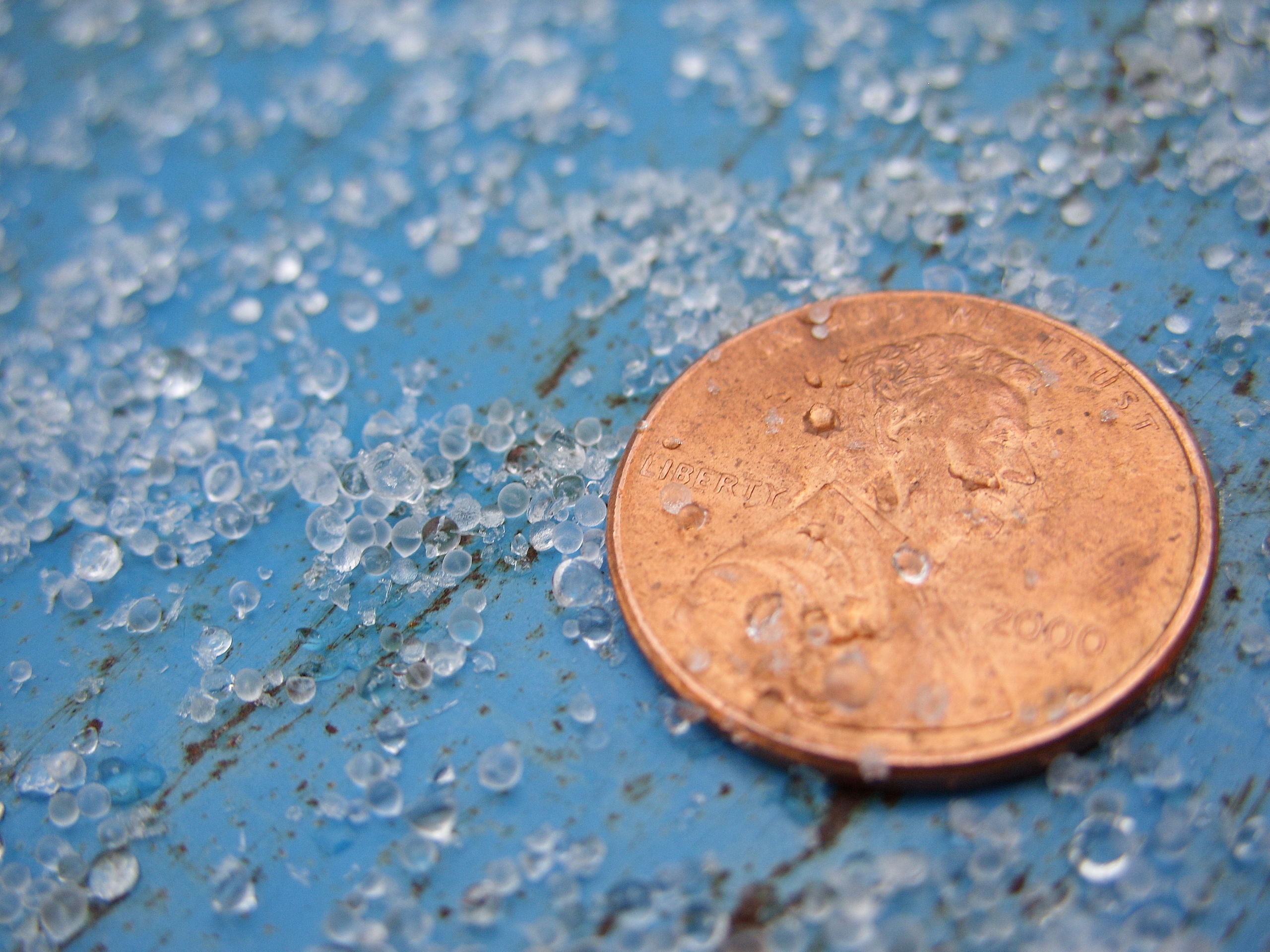
Perhaps graupel is a type of wintry precipitation that may be new to you. Graupel is formed by convection. In meteorology, convection is defined as “…vertical transport of heat and moisture in the atmosphere, especially by updrafts and downdrafts in an unstable atmosphere. The terms “convection” and “thunderstorms” often are used interchangeably, although thunderstorms are only one form of convection.” Graupel can be thought of as a hybrid between sleet and hail. These Dippin’ Dots from the sky occur when there is very cold air in the upper parts of a shower or squall, and the surface is just above freezing. Because graupel occurs with convection, lightning is often seen. 


Graphic via NWS Wilmington, OH showing the differences between graupel, hail, and sleet.

Was recording the heavy graupel for my Snapchat when in captured lightning on video, and a pretty loud crack of thunder. Thunder-graupel in Altoona!!!! #PAwx @NWSStateCollege @JoeMurgo pic.twitter.com/hgZLNCaNa9

— Nick Wilkes (@nickwilkeswx) April 10, 2020

Freezing Rain

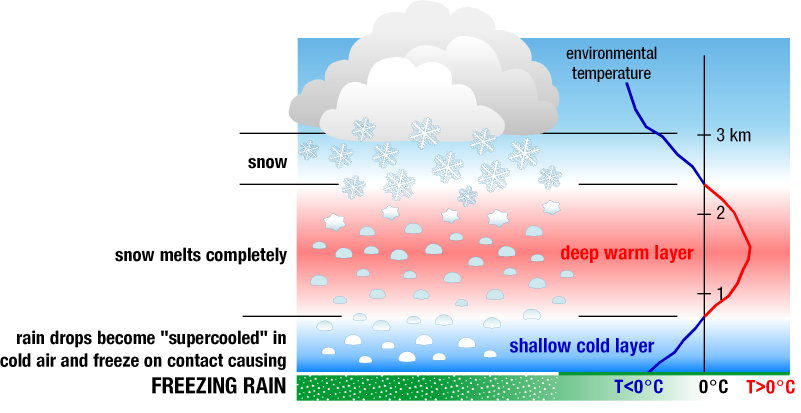
When plain ole’ rain freezes upon contact with the ground, that is freezing rain. Snow falls through a deep warm layer of the atmosphere, turning to rain; however, if the surface temperatures are at or below freezing, the rain doesn’t have time to freeze into pellets. Anything that is at or below freezing, such as trees, powerlines, or even the ground, freeze over instantly as rain touches them. Accumulating ice can weigh down tree branches and powerlines, which leads to power outages.


Freezing rain graphic via the National Weather Service.

Photo was taken by the author, showing ice accretion caused by freezing rain on a sparkleberry bush in Altoona, PA on February 16, 2016.

Sources:

Severe Weather 101: Winter Weather Types

Glossary – NOAA’s National Weather Service

Filed Under: blog-3

December 28, 2020 By Nick Wilkes

Meteo Monday-Snow Squalls

Maybe you’ve experienced this situation. You’re driving down the highway, the weather is fine. You can see some clouds off in the distance, but you’re not concerned. A few miles later, you encounter a sudden white-out with no visibility. Snow and ice cover the road, and your car just slid into the median. You drove right into a snow squall! 

In this week’s Meteo Monday, we are looking at snow squalls, particularly “frontal snow squalls”. We will tackle lake-effect snow and lake-effect snow squalls in a future Meteo Monday.


Photograph by the Author of a snow squall that pushed through Altoona, PA on December 30, 2017. The reduced visibility and quick accumulation of snow on the roadways led to several wrecks around town.

Per the National Weather Service (NWS) Glossary: “A snow squall is an intense, but limited duration, period of moderate to heavy snowfall, accompanied by strong, gusty surface winds and possibly lightning (generally moderate to heavy snow showers). Snow accumulation may be significant.”  A frontal snow-squall forms along a “convective line” similar to Quasi-Linear Convective System (QLCS) thunderstorms in the warmer seasons. These low-topped convective cells can be hard to pick up on radar as they typically only grow to 5,000-10,000 feet tall.


A Snow Squall moving through Central Pennsylvania on December 18, 2019. It was close to the NWS Radar, therefore, was visible. The light blue polygon is a Snow Squall Warning.

Snow squalls pose an extreme risk to people who are driving on highways. The combination of quickly reduced visibility and sudden slick conditions of the roads often leads to high-speed pile-ups. Sadly many of these wrecks are deadly. Snow squalls are very common in portions of the  Northeast. Though they can occur anywhere where a “convective line” can form and the temperatures are cold enough to support snow.


“Aerial view of I-80 near Milesburg, PA on January 6, 2004, after an arctic front and associated snow squall caused a massive pileup.” via NWS State College.

The National Weather Service will issue snow squall warnings for intense squalls. Per the NWS: “A snow squall warning is a short-fused warning product (normally 30-60 minutes) used to warn of an intense, short-lived burst of heavy snowfall. They will be issued for a combination of quick reduction in visibilities (less than 1/4 mile), sudden whiteout conditions, and slick/hazardous roads.” Snow Squall Warnings will trigger the Wireless Emergency Alert (WEA) on your phone, similar to tornado warnings. Not all snow squalls will get a warning.

A graphic of a snow squall warning issued by NWS State College on December 18, 2019. Note this is for the same snowsquall that is seen in the above photo of the radar.
The text of the snow squall warning.

What should you do if you’re caught in a snow squall? The best thing to do is to avoid all travel. So if you can, delay your travel until after it passes. However, if you’re already on the road when a squall strikes, here are a few things to do to stay safe. 

  • Slow down! The slower you’re going, the easier it will be for you to stop if you need to.
  • If you are having trouble seeing, pull off to the side of the road until visibility improves. Turn off your lights and use your parking brake so another car won’t mistakenly follow your tail/brake lights and end up hitting you. 
  • If your car starts to slide, stay calm! Ease your foot off the gas and turn your wheels in the direction you want the car to go. If your car is equipped with an anti-lock braking system (ABS), do not pump the brakes, apply steady pressure to the brake pedal. 

Winter is upon us and snow squalls are just one of the many hazards of wintry weather! Being prepared and knowing what to do in the event of a squall to stay safe is a must if you’re in an area that deals with them frequently! 

Sources

https://w1.weather.gov/glossary/index.php?word=Snow+squall+

https://www.weather.gov/ctp/HISA

https://www.weather.gov/media/iln/winter/SnowSquallBrochure.pdf

https://www.weather.gov/media/iln/winter/SnowSquallBrochure.pdf

https://www.weather.gov/bou/watchwarningadvisoryexplained

https://mesonet.agron.iastate.edu/vtec/#2019-O-NEW-KCTP-SQ-W-0009/USCOMP-N0Q-201912181930

https://www.weather.gov/safety/winter-during

Filed Under: blog-2

December 17, 2020 By Nick Wilkes

“The Christmas Star”

Many people know that around December 21 of each year, the Winter Solstice arrives. However, it wouldn’t be 2020 without something out of the ordinary happening! This year during the solstice we are in for a treat, with what many are calling “The Christmas Star.” The conjunction of Saturn and Jupiter will be responsible for this “star.”  It is, however, not actually a star.


Image of the Jovian Planets via Laboratory For Atmospheric and Space Physics as part of a NASA funded initiative.

These two Jovian Gas Giants will appear to merge into one “star”  on the evening of December 21, they however still remain millions of miles apart. The fact that this is occurring on the winter solstice is just merely a coincidence. Conjunctions of planets like this can happen on any day of the year. Henry Throop, an astronomer with NASA said, “The date of the conjunction is determined by the positions of Jupiter, Saturn, and the Earth in their paths around the Sun, while the date of the solstice is determined by the tilt of Earth’s axis. The solstice is the longest night of the year, so this rare coincidence will give people a great chance to go outside and see the solar system.”

If you want to view the conjunction, all you have to do is find an unobstructed view of the southwest sky. When you look up, you’ll see what looks like a large “star” in the sky. Even if you live in a major city, these planets are bright enough to be seen on a typical night, but when they appear to “merge” it will be even brighter and very easy to see.


Graphic via NASA on where to look to view the conjunction.

What makes this one special is that the last time the planets appeared to be this close in the sky was in 1623 and it was dubbed “the Great Conjunction”  by Galileo Galilei who observed it. The last time that a conjunction between Jupiter and Saturn occurred at night was nearly 800 years ago in 1226!  The next one will occur in 2080. So be sure to get outside on the evening of December 21, if weather permits, and check out the “This Christmas Star”!

Sources

http://lasp.colorado.edu/outerplanets/giantplanets_whatandwhere.php

https://www.nasa.gov/feature/the-great-conjunction-of-jupiter-and-saturn

https://www.nationalgeographic.com/science/2020/12/see-rare-great-conjunction-of-jupiter-saturn-on-winter-solstice/

Filed Under: blog-3

December 13, 2020 By Nick Wilkes

Meteo Monday-Blizzards

In this week’s Meteo Monday, we are taking a look at blizzards! Blizzards are very impactful winter storms, but there are a lot of misconceptions as to what a blizzard actually is. Many people think that any big snowstorm is a blizzard. This is not true. To be a blizzard, a snowstorm has to have blowing snow and reduced visibility. You can have a blizzard with just one to two inches of snowfall accumulation.


A photo taken during a blizzard in Minneapolis, MN, on December 12, 2012. Photo via Wikimedia Commons.

Per the American Meteorological Society (AMS) for a snowstorm to be classified as a blizzard it must reach each of these criteria for three consecutive hours or longer: 

  • Sustained wind or frequent gusts of at least 35 mph or higher 
  • Falling and/or blowing snow that reduces visibility to less than a quarter of a mile (0.25 miles). 

Past criteria included low temperatures of 20℉ or colder, but this is no longer required.

There is also what is known as a ground blizzard. A ground blizzard is caused when an Artic cold front accompanied by strong winds moves across an area that has freshly fallen snow. The wind whips the snow up creating a whiteout. One of the worst blizzards in US history was a ground blizzard on January 12, 1888. Per the NWS: “One of the most infamous ground blizzards was the Children’s Blizzard of 1888, which killed an estimated 235 people in the Great Plains. This ground blizzard was extremely dangerous because it was preceded by unseasonably warm air, which caused people to let their guard down. Many people ventured outside without proper winter clothing, but the relatively warm weather did not last long.”


Some notable blizzards include; 

  • The 1950 Great Appalachian Storm: You can read our retrospective here. 
  • The “Great Blizzard of 1978”:  Also called the “Cleveland Superbomb”, this blizzard produced wind gusts over 100 mph! 
  • The 1993 “Storm of the Century”: This storm brought heavy snow and blizzard conditions from Alabama northward into New England.
  • The Blizzard of 1996: Paralyzed parts of the Eastern U.S. with over four feet of snow.
  • “Snowmageddon” in 2010:  Massive snow and blizzard conditions occurred across parts of the Mid-Atlantic. Dulles Airport had its greatest snow on record, 32.4 inches.

Ironically, there has even been a hurricane-induced blizzard! On October 30th, 2012, the morning after Sandy made landfall in NJ, a blizzard occurred from the mountains of western North Carolina, through West Virginia, into Southwestern PA. Tropical storm to hurricane-force winds and several feet of snow produced widespread damage across this area.


Map from NCDC showing the snowfall totals produced by Hurricane Sandy.

Sources: 

https://en.wikipedia.org/wiki/Blizzard

https://glossary.ametsoc.org/wiki/Blizzard

https://www.weather.gov/safety/winter-ground-blizzard

Filed Under: blog-3

December 11, 2020 By Nick Wilkes

The Geminid Meteor Shower!

Over 100 meteors are recorded in this composite image taken during the peak of the Geminid meteor shower in 2014. 
Credit: NASA/MSFC/Danielle Moser, NASA's Meteoroid Environment Office)
Over 100 meteors are recorded in this composite image taken during the peak of the Geminid meteor shower in 2014.
Credit: NASA/MSFC/Danielle Moser, NASA’s Meteoroid Environment Office)

The Geminid meteor shower has been active! It began December 1, and is expected to end around December 22. The peak of the shower will be on the night of December 13 into the morning hours of the 14th. The Geminids are considered by the American Meteor Society (AMS), the most dependable and vibrant meteor showers of the year. The meteors are often bright and intensely colored. During its peak, up to 120 meteors are visible per hour!

The Geminid meteor shower gets its name as their apparent radiant (point in the sky they appear to come from) is in the constellation Gemini. NASA denotes: “The constellation for which a meteor shower is named only serves to aid viewers in determining which shower they are viewing on a given night. The constellation is not the source of the meteors. Also, you should not look only to the constellation of Gemini to view the Geminids — they are visible throughout the night sky.” 

What is a meteor shower and what makes the Geminids different from other meteor showers? Per the AMS: “Most meteor showers have their origins with comets. Each time a comet swings by the sun, it produces copious amounts of meteoroid sized particles which will eventually spread out along the entire orbit of the comet to form a meteoroid “stream.” If the Earth’s orbit and the comet’s orbit intersect at some point, then the Earth will pass through this stream for a few days at roughly the same time each year, encountering a meteor shower.” 

The Geminids are NOT caused by a comet. They are in association with the 3200 Phaethon asteroid, which orbits the sun closer than any other asteroid. This asteroid gets its name from Phaëthon the son of the Greek god of the sun, Helos.  The Geminids first appeared in the mid 1800s.


Graphic on where to look to see the meteor shower (NASA).

How can you view the meteor shower? According to NASA: “The Geminids are best viewed during the night and predawn hours and are visible across the globe due to a nearly 24-hour broad maximum. This shower is considered one of the best opportunities for young viewers since this shower starts around 9 or 10 p.m”  Here are a few tips on how you can best observe the Geminids: 

  • Find an area well away from city or street lights.
  • Be prepared for cold temperatures.  Bring a sleeping bag or a blanket.
  • Lie flat on your back with your feet facing the south and look up. After about 30 minutes your eyes should be adjusted to the dark. 
  • Be patient! You may not see anything right away.  Luckily the meteor shower will be going through the night. 

Sources: 

https://www.amsmeteors.org/2020/12/viewing-the-geminid-meteor-shower-in-2020/

https://www.amsmeteors.org/meteor-showers/meteor-faq/#5

https://solarsystem.nasa.gov/asteroids-comets-and-meteors/meteors-and-meteorites/geminids/in-depth/

https://solarsystem.nasa.gov/resources/2567/whats-up-december-2020-video/

Filed Under: blog-3

  • « Previous Page
  • 1
  • 2
  • 3
  • Next Page »

Real Personalities

When looking to add a trusted source for weather, you want someone who can connect with your audience.   Our meteorologists are also on-air personalities.    The Storm Report team delivers a fresh sound with relatable information to get through the day.  We are your staff meteorologists.

The Storm Report

Follow us on:

Real Passion

We love weather.   No two days are the same.   That fuels our passion.   When weather is serious, you will hear it in our voices.    No text-to-speech computer forecasts.   No robotic audio.   Humans connect with humans and that is what radio is all about.

Real Life

When your community hosts special events, the weather is always a factor.   We weave timely information into your forecast when it comes to fairs, parades, fundraisers or remote broadcasts.    If your weather is sponsored, we are the spokesperson, helping your client earn results.

Copyright © 2026 thestormreport.com