The Storm Report

  • Home
  • Radio Weather
  • Staff
  • Interactive Radar
  • Contact Us

February 26, 2021 By Dan Holiday

Understanding Thunderstorm Risks Can Help You Prepare for Severe Weather

While most of us are still in darkness under the Groundhog’s shadow, the change in seasons will soon be underway.  Every year we leave it to a rodent to make a generalized weather outlook, but the human team at the Storm Prediction Center do the real forecasting and have a lot of responsibility on their hands.   

Each weather scenario is different, and when the threat of severe storms rears its ugly head, it is the job of the SPC to let us know how to plan our lives in order to remain safe.

Doing that begins with data derived from an old-fashioned yet high-tech weather balloon. From there, the business of weather gets risky.

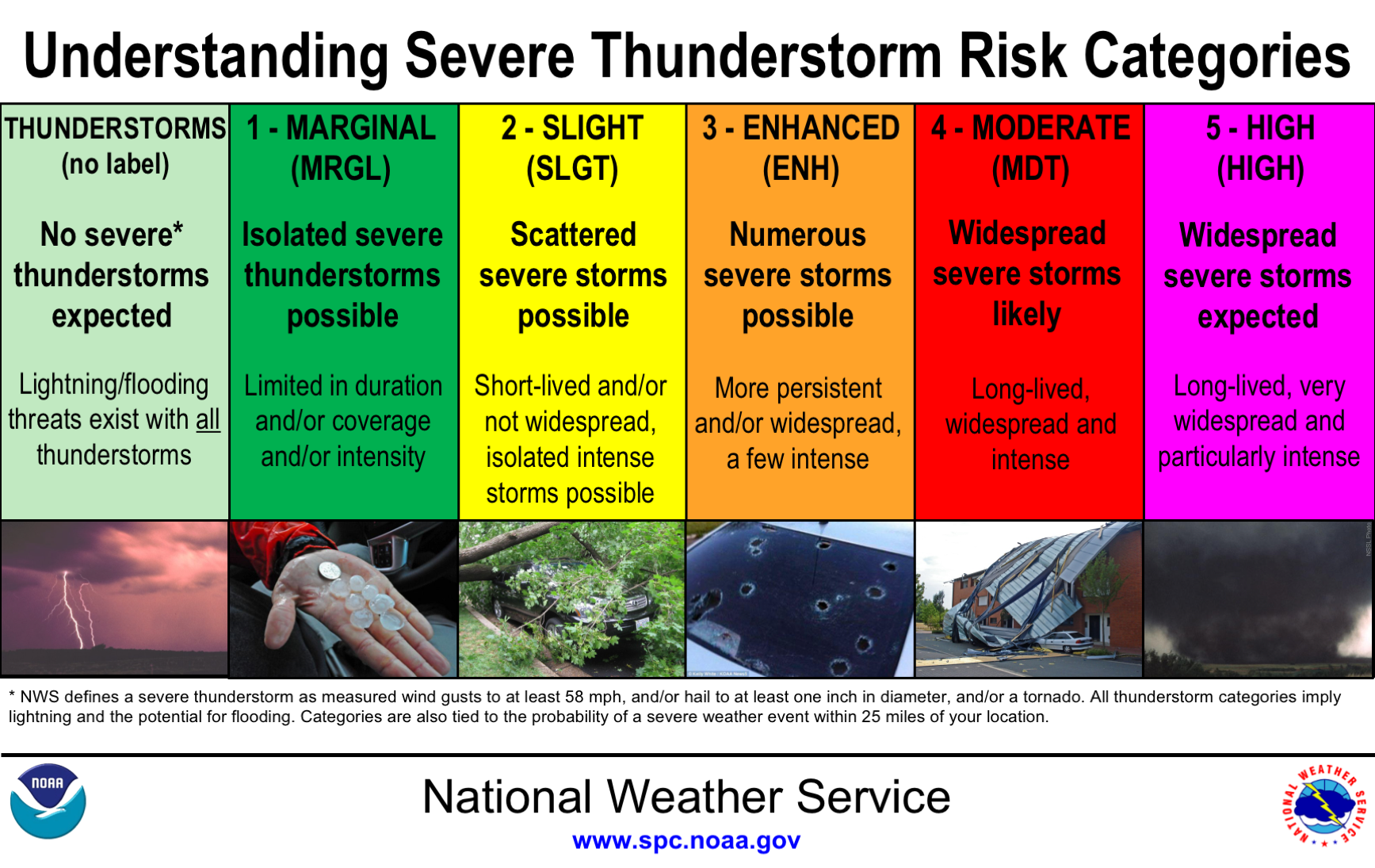
After compiling the data, the Storm Prediction Center places various areas of the country in a color-coded categorical risk.  Light green means basic thunderstorms.  A marginal risk is a dark green area of the map.  Yellow indicates a slight risk.  The fourth tier is an enhanced risk (orange). The next two levels get more attention than the others; moderate (red) and high risk (magenta).


These risks are issued up to three days out and can change over time. And while the color and their meaning seem obvious, they are a little more detailed than you might think.   

Alex Forbes is an undergraduate at Mississippi State University.  He told The Washington Post last year that while weather enthusiasts grasp what these risks mean, most of the general public do not.  In a research project, Forbes asked 4,000 respondents to rank the order of the five categories.  Those surveyed got 4 out of 5 wrong.  However, most of them did understand that “high risk” means the worst level of concern. 

The Storm Prediction Center uses the following criteria to help them decide what level of risk to issue when thunderstorms are possible.

The general thunderstorm risk indicates where a 10% or greater probability of thunderstorms is forecast.  Usually, these storms aren’t severe.

A marginal risk means storms are likely severe but limited in organization and may not necessarily last long.  The coverage is usually low, and the intensity is marginal.

A slight risk signals an area of organized severe storms, which is not widespread in coverage but might have variable levels of intensity.  

The enhanced risk is fairly new and debuted in the fall of 2014.  It means an area of greater severe storm coverage with intensity quite variable. 

Media attention and hype rises the greater the risk becomes. That’s why extensive thought and discussion go into issuing a moderate risk.  This is a region where widespread severe weather is likely, including several tornadoes and/or numerous severe thunderstorms, which should be intense.  What makes the moderate more concerning is that strong tornadoes, very large hail or a widespread line of damaging winds are possible on those days.   

On days when a severe weather outbreak is likely, a rare high risk is issued.  It’s reserved when confidence is itself high, and damage to life and property is likely.  High risks often indicate a threat of numerous strong and long tracked tornadoes or a thunderstorm complex producing hurricane-force winds over a large area.   

Severe weather and tornadoes were missing from much of the country at the peak of last year’s season.   If 2021 is more active, understanding the risk levels issued can help make you more prepared. 

Sources:

The Storm Prediction Center

Filed Under: blog-2

February 22, 2021 By Nick Wilkes

Meteo Monday – Unique Cloud Types

Have you ever stepped outside and looked up into the sky to see what looks like a UFO shaped-cloud? What about clouds that look like waves? In this week’s Meteo Monday, we are getting our “head out of the clouds” and delving into the meteorology of unique cloud types.


A wall cloud over Ocean City MD on July 18, 2016, took on the shape of a cinnamon bun. The author took this photo.

Mammatus Clouds

Mammatus clouds are often seen during severe thunderstorms. The name mammatus is derived from the Latin “mamma,” meaning “udder or breast” and can be thought of as “mammary clouds.” These clouds can be very ominous looking, and there is uncertainty on how they are created. One hypothesis suggests that they are formed when there is a lot of wind shear (the changing of wind direction or wind speed with height) along with sharp gradients in temperature and moisture. 


Mammatus clouds over Altoona, PA, on May 5, 2020. Photo from the author.

Lenticular Clouds

Lenticular clouds look like UFOs that form in hilly or mountainous areas. These form when moist, stable air flows over an eddy, usually caused by mountains or hills. If the dewpoint and temperature meet and condensation occurs, as the air moves through this eddy, a lenticular cloud is formed, often on the leeward side of the mountain.  Some people believe that these clouds are responsible for UFO sightings.


Lenticular clouds, location unknown, via Pixabay.

Arcus Clouds

Arcus clouds are low-horizontal cloud formations that often are associated with storm clouds. Many people are familiar with shelf clouds that form along the gust front or leading edge of a severe thunderstorm. Shelf clouds are just one type of arcus cloud. Another type is called a roll cloud. This is similar to a shelf cloud, but it is not attached to a cloud base. They can form with sea breezes and cold fronts without thunderstorms present.


Photo from Giovanni Rizzotti, showing a shelf cloud in association with a severe thunderstorm at Ocean City, MD on August 23, 2020.

Kelvin-Helmholtz  Instability Clouds

The name of this cloud type is a mouth-full “Kelvin-Helmholtz Instability Clouds.” These rare clouds get their name from the physicists who studied turbulent airflow, Hermann Helmholtz and Lord Kelvin. They can occur on windy days when you have different wind speeds at different heights. Per the UK Met Office: “When the upper layer of air is moving at a higher speed than the lower-level air, it may scoop the top of an existing cloud layer into these wave-like rolling shapes. Kelvin-Helmholtz instability is a scientific phenomenon not exclusively associated with clouds.” 


Kelvin-Helmholtz Instability Clouds over San Fransisco in 2006 via Wikimedia Commons.

Have you seen any of these clouds we talked about in our article? If so send us your photos to our Facebook and Twitter @thestormreport or use the hash-tag:  #meteomonday. 

Sources:

Mammatus cloud

Lenticular cloud

Arcus cloud

Kelvin-Helmholtz clouds

Filed Under: blog-3

February 13, 2021 By Jennifer Narramore

Historic Winter Storm and Life Threatening Cold To Hit the U.S.

Over 100 million Americans are currently under winter-related watches, warnings, or advisories as a significant winter storm moves out of the Pacific Northwest and across the Rockies. This system will be diving through the Plains and Deep South and then moving up through the Ohio Valley and into the Northeast.  The Arctic air mass we talked about in last week’s Meteo Monday continues to penetrate further southeast, so not only are we dealing with accumulating snow and ice for several areas across the country but the potential for record-breaking cold.

This storm has packed a punch across parts of the Pacific Northwest. Portions of Oregon have picked up over an inch of ice-accretion, which has led to nearly 300,000 power outages. 8-10” of snow has fallen across the Seattle Metro Area, and over a foot has fallen across the Vancouver, WA metro.

CRAZY! The weight of the snow collapses the roof of this boat dock in the Willamette River. House boats tipping, too. At the end of the vid, one man is escaping w/ what looks like a pet kennel! I hope everyone is safe. Caution: language

📷: John Kinsman around 4AM@fox12oregon pic.twitter.com/fETGx8YNzA

— Brenna Kelly (@BrennaKellyNews) February 13, 2021

The National Weather Service in Dallas, TX, is calling this a historic storm. “Major impacts resulting in severe stress to the region`s infrastructure (particularly power, water, and highways) are likely. Regional travel will be crippled for days.” They are also saying that these will be some of the region’s coldest temperatures since the December 1989 Arctic Outbreak. 

Portions of Louisiana that are still recovering from the devastating 2020 hurricane season will now have to go through a significant ice storm late Sunday night into Monday. NWS Lake Charles is projecting 0.10” to 0.30” of ice accretion across their County Warning Area (CWA). This will lead to tree damage, power outages and make driving impossible.


Image via NWS Lake Charles.

Below are the Weather Prediction Center (WPC) Winter Precipitation Guidance maps. These maps are valid from 7:00 AM EST Saturday through 7:00 AM EST Tuesday. They show the probability of greater than 4” of snow accumulation and ice accumulation greater than a quarter inch. 


snow

freezing rain

Not only are we dealing with this winter storm, but there is also a severe weather threat. The Storm Prediction Center has a slight risk (level 2 out of 5) of severe thunderstorms across portions of the Florida Peninsula for Sunday.  The main threat is damaging winds, but isolated tornadoes are possible. 

Sources:

NOAA

Pivotal Weather

Filed Under: blog-2

February 11, 2021 By Jennifer Narramore

St. Elmo’s Fire!

One of my movie-star crushes from the 80s was Rob Lowe. (I know I just aged myself).  He was a member of the brat pack and one of the stars of the 1985 coming of age movie, St. Elmo’s Fire. The plot revolves around a group of recent graduates from Georgetown University trying to navigate the waters of life after college. In one scene, Rob’s character Billy is attempting to help his friend Jules, played by Demi Moore, through her breakdown. He tells her that the drama she is in the midst of isn’t real.  It is just like St. Elmo’s Fire. He then explains this phenomenon as “electric flashes of light that appear in dark skies out of nowhere. Sailors would guide entire journeys by it, but the joke was on them, there was no fire, there wasn’t even a St. Elmo. They made it up.”

https://www.youtube.com/watch?v=20GcL1nyzE8

Hold the presses, Billy! This meteorologist must object! St. Elmo’s Fire is a real phenomenon, and there was a St. Elmo. Let’s look a little deeper, shall we?

St Elmo's Fire on the windshield of a passenger jet last night as it passed south of the Fultondale storm/tornado last night. Photo from Ziggy Jirik pic.twitter.com/AKT1Egg6N9

— James Spann (@spann) January 27, 2021

Per NOAA, “St. Elmo’s Fire is a colorful discharge of atmospheric electricity that typically occurs during a thunderstorm. When a sharp object (such as a ship’s mast) comes in contact with an extraordinarily high electrical field and a large number of electrons, the electrons can glow in various colors, like a neon sign, resulting in this rare phenomenon.”  The glow is a blue or violet color, and the sharp object could also be spires, chimneys, and even aircraft wings. 

https://youtu.be/Lgv-3ITbOm4

Billy was on the right track about sailors and their connection to St. Elmo’s Fire. But he was incorrect in stating there was not a St. Elmo. One of the patron saints of sailors was St. Erasmus of Formia, also known as Elmo. He was an early Christian bishop and martyr.  


Painting of Saint Erasmus via Wolfgang Sauber, CC BY-SA 4.0 , via Wikimedia Commons

How did Elmo become a saint to the sailors?  During my research on this topic, I found a story stating that Erasmus was preaching, and lightning struck the ground near him. He survived. Sailors began to believe that Elmo could protect them from storms while at sea. During a thunderstorm, that “colorful discharge of atmospheric electricity” would sometimes be seen on a masthead. Sailors would see that as the presence of Elmo. The phenomenon, St. Elmo’s Fire, is named after St. Erasmus.  

Typically, paintings depicting Elmo (like the one above) show him holding a windlass, an apparatus for hoisting heavy weights.  On a boat, it can be used to help raise an anchor.  This icon also signifies Elmo as a patron of sailors.  

St. Elmo’s Fire was observed during a tornado outbreak in 1955. In an article entitled, “Storm Electricity Aspects of the Blackwell/Udall Storm of 25 May 1955”, Don Burgess documents the “unusually vigorous electrical activity” seen during this event.  Burgess was 8-years-old and observed the storm’s early life from the western edge of Stillwater, OK. He notes, “Later, as the nighttime Blackwell tornado formed south-southeast of Tonkawa, it was made visible by frequent lightning flashes. At Blackwell, very frequent cloud-to-ground lightning was observed ahead of the tornado, and unusual electrical activity was seen in and around the tornado. Very bright electrical discharges were seen within the funnel and ground-originating corona current (also known as St. Elmo’s Fire) was seen just ahead of the tornado.”

Sources:

Top Five: Weird Ocean Phenomena – NOAA

St. Elmo’s Fire – Wikipedia

St. Erasmus – Britannica

Who are the Three Patron Saints of Sailors? – Elmo, Christopher and Brendan

Saint Erasmus of Formiae (or Saint Elmo)

What Is St Elmo’s Fire?

Norman, OK  Weather Forecast Office Storm Electricity Aspects of the Blackwell/Udall Storm of 25 May 1955

Filed Under: blog-3

February 8, 2021 By Jennifer Narramore

Meteo Monday – The Polar Vortex!

A frigid air mass has been pushing into parts of the country and you may have heard some rumblings in the news that even more cold air is on its way!  Here are some of the headlines that may have graced your social media feed. 

“Coldest Air of the Season Plunges into the U.S.” 

“An Arctic Air Mass Will Invade the Country”

“Chunks Of The Polar Vortex Will Bring Bitterly Cold Wind Chills”

Oh no!  The Polar Vortex!  Is it here?  AGAIN?!  Run for your lives!

Yes!  The Polar Vortex is here, and it is real!  And we are going to talk about it in this latest version of Meteo Monday!

So, what is a polar vortex?  Per the National Weather Service (NWS), “The polar vortex is a large area of low pressure and cold air surrounding both of the Earth’s poles. It ALWAYS exists near the poles, but weakens in summer and strengthens in winter. The term “vortex” refers to the counter-clockwise flow of air that helps keep the colder air near the Poles.”  The vortex always exists, and it is not a new phenomenon.


Image via NOAA.

Winter for a good part of the United States is…cold. However, there are times where it gets much colder than average. Plunges of arctic air masses are caused when the jetstream links up with a piece of the polar vortex and pulls the frigid air southward into the lower 48. Using the term polar vortex to describe these cold shots became mainstream in the winter of 2013/2014 when the national media ran headlines about it. Since then, every cold snap has been labeled “polar vortex.”  It is important to stress that this is not a new term and that meteorologists started using the phrase in 1853!

Why do you see these news headlines about the polar vortex? First of all, The Climate Prediction Center (CPC) 6-10 day outlook over the past few weeks, has consistently shown temperatures across a good part of the country well below average.


Latest 6-10 Day Temperature Outlok from the Climate Prediction Center (as of Feb 8).

Current weather computer models show that the coldest temperatures will likely occur just before sunrise on Valentine’s Day. We want to stress that this is not a forecast, it is a model’s interpretation, and things have changed and will continue to do so as we are still several days away. It is difficult to forecast who will get the coldest air. We have been looking at the model runs for the past several days. They continue to show that frigid temperatures will seep further south. But where exactly will this set up? 

Take a look at the Global Forecast System (GFS Model) slated for 12z (7:00 am EST on the 14th). The image at the top shows the forecast from Saturday, February 6, and the image at the bottom shows the forecast from today (February 8). Notice a shift in where the coldest air will be based on the model runs.  Saturday’s run had the arctic air stretching from the Northern and Central Plains eastward into the parts of the Ohio Valley and the Northeast. Today’s model interpretations are showing the coldest air much further west. This air mass is forecast to stay from west of the Mississippi River through the Northern and Central Plains and over the Rockies. Also a nose of colder air could settle into Texas and New Mexico. 


GFS Model Run from Saturday, February 6. Image credit: WeatherBell Analytics.

GFS Model Run from Monday, February 8. Image credit: WeatherBell Analytics.

No matter how cold it gets, it is essential each winter season to review your safety plan. Arctic blasts typically occur each season, some worse than others.  And some lasting longer than others.  Arctic air combined with brisk winds can lead to extremely cold wind chill temperatures. Per the NWS, “The wind chill temperature is based on the rate of heat loss from exposed skin caused by wind and cold and is to give you an approximation of how cold the air feels on your body.” The NWS issues Wind Chill products to alert the public of dangerous cold.  


Image via NWS.

When venturing outside in the extreme cold, make sure to dress in layers. One of the dangers of the bitter cold is frostbite. Per the NWS, “Frostbite happens when the body’s survival mechanisms kick in during extremely cold weather. To protect the vital inner organs, the body cuts circulation to your extremities: feet, hands, nose, etc., which eventually freeze.” If you have to go out, make sure to cover every part of your body.  Stay out of the wind and limit your time outside.  Frostbite can occur within five minutes when wind chill values are -50°F or below. If your body temperature lowers to below 96°F, you have hypothermia. This is a severe health condition, and you must seek medical attention immediately. 


Image via NWS.

Other things to consider when an arctic air mass is on its way:  Protect your pets or farm animals.  Limit their exposure to the cold and make sure they have plenty of food and water. Take precautions to keep the pipes at your home or business from freezing. Keep at least a half tank of gas in your vehicle and prepare a winter car survival kit.  Items to include: jumper cables, a flashlight, first aid kit, a shovel and ice scraper, extra clothes, and blankets. 

So, whether the headline includes the words “polar vortex” or some other frigid phrase, remember it is winter, and periods of extreme cold are nothing new.  The goal is to be prepared and stay safe.  Think warm! Meteorological spring is only a few weeks away!

Sources:

Cold Weather Safety

What is the Polar Vortex? – Weather.Gov

Polar vortex

WeatherBELL Analytics

Climate Prediction Center – 6 to 10 Day Outlooks

Filed Under: blog-3

  • « Previous Page
  • 1
  • 2
  • 3
  • 4
  • …
  • 8
  • Next Page »

Real Personalities

When looking to add a trusted source for weather, you want someone who can connect with your audience.   Our meteorologists are also on-air personalities.    The Storm Report team delivers a fresh sound with relatable information to get through the day.  We are your staff meteorologists.

The Storm Report

Follow us on:

Real Passion

We love weather.   No two days are the same.   That fuels our passion.   When weather is serious, you will hear it in our voices.    No text-to-speech computer forecasts.   No robotic audio.   Humans connect with humans and that is what radio is all about.

Real Life

When your community hosts special events, the weather is always a factor.   We weave timely information into your forecast when it comes to fairs, parades, fundraisers or remote broadcasts.    If your weather is sponsored, we are the spokesperson, helping your client earn results.

Copyright © 2026 thestormreport.com