The Storm Report

  • Home
  • Radio Weather
  • Staff
  • Interactive Radar
  • Contact Us

January 10, 2021 By Steve Hamilton

Winter Weather Warnings, Explained

Since it is winter in the Northern Hemisphere, we thought it would be a good idea to explain a little bit about the variety of winter weather watches, warnings and advisories. During these cold months, you’ll probably hear some of these terms in the weather forecast, but we will give you a better idea of just what they mean.

The first thing to keep in mind, is that the National Weather Service sets its watch, warning and advisory criteria depending on location or region. For example, snow in New York City is not as big a deal as it would be in a city in the south, where bad winter weather conditions are less frequent. This mostly has to do with what are considered typical types of winter weather for a specific area, and what people are accustomed to dealing with. While 3 inches of snow in New York might be a nuisance, 3 inches of snow in Dallas or Atlanta might cause much bigger problems because people there may not be used to that kind of weather.


Image via ready.gov
Image via ready.gov

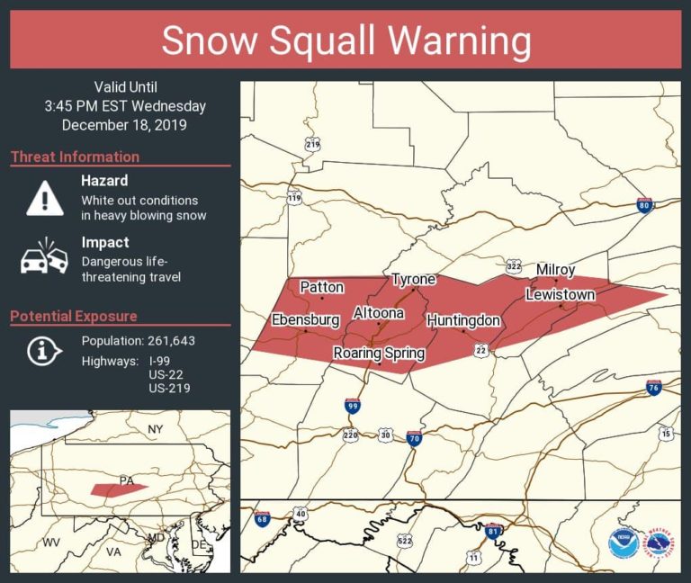
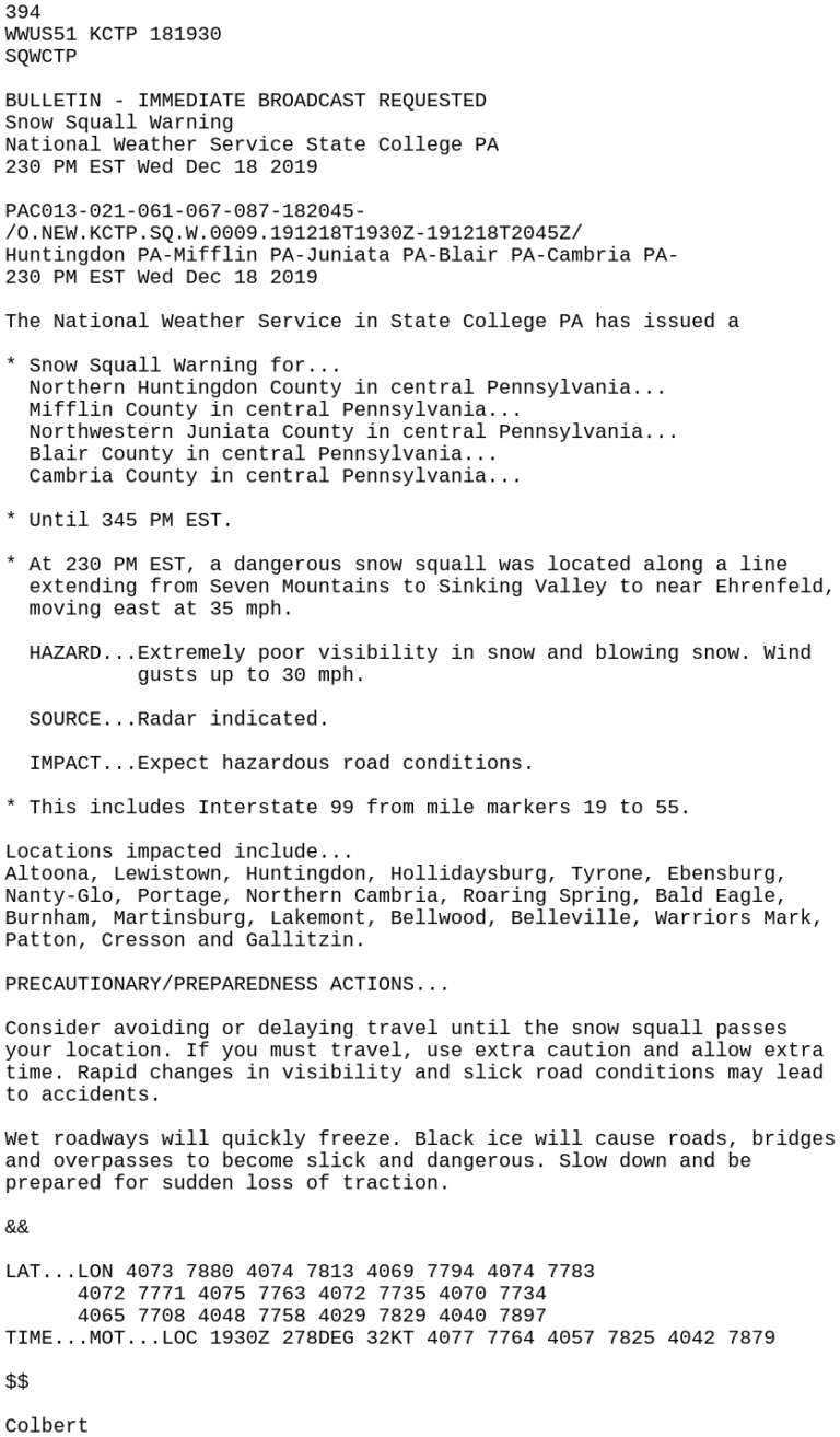
Watches and Warnings are issued by National Weather Service regional offices, and they go by county, and usually cover a wide area, often including several states.

Here are a couple of watches and warnings you will hear a lot over the winter, if you live in a snow-prone area: Winter Storm Watches, and Warnings. The difference between a Watch and a Warning is straightforward. A Watch means conditions are favorable for dangerous weather conditions. A warning means winter storm conditions are imminent or occurring.

First off, here’s the NWS definition of a “winter storm”: 5 inches or more of snow or sleet in a 12 hour period, or 7 inches or more of snow or sleet over a 24 hour period. There are a few other elements that could come into play, like enough ice accumulation, mainly freezing rain, to cause damage to trees and power lines, or a life-threatening or damaging combination of snow and ice, with gusty wind.

Now here are a few you might not be familiar with. For example, an “Ice Storm Warning”. Those aren’t much fun, and they’re issued when a quarter inch or more of ice accumulation is expected. Usually, that will be freezing rain, which is precipitation that falls as liquid, and freezes when it hits the surface. A quarter inch of ice is heavy enough to cause tree damage and power outages, not to mention very hazardous driving and walking conditions.


Image via NOAA National Weather Service.

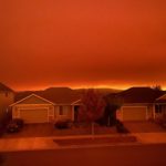
You have probably heard the term “Blizzard Warning”. So, what exactly is that? A Blizzard Warning is a bit different from a Winter Storm Warning, mainly because focuses more on wind and visibility. Basically, winds of 35 mph or greater, and visibility of a quarter-mile or less, constitute a Blizzard Warning.

There is a prevalent misconception that a Blizzard Warning means it will be extremely cold, or there will be heavy snowfall. However, there is no temperature requirement for a Blizzard Warning, and snow does not actually have to be falling. Snow that is already on the ground, combined with the wind, could meet the low visibility requirements for a Blizzard Warning.

The next one does have to do with cold, and that is a “Wind Chill Warning”. It means wind chill temperatures of minus 25 degrees or lower are expected in the next 12 to 36 hours. During a Wind Chill Warning, you should either stay in a warm place, or have the right type of clothing to protect yourself completely against the cold. Even though it may be sunny, wind chill can cause frostbite on exposed skin, and possibly hypothermia, quite quickly.

Those are the biggies. Now, you might hear the word “Advisory” associated with hazardous winter weather. That means the dangerous winter conditions we talked about are likely, but not bad enough to meet the criteria for a warning. But that does not mean it won’t be dangerous. And again, that depends on where you are located. An advisory for snow in New York might qualify as a warning for a place like Atlanta.

This is a lot to remember. But when you hear the words “watch”, “warning” or “advisory” in a winter weather forecast, you should pay close attention to the forecast so you’ll know what to expect and figure out how the conditions will affect your situation.

Always have enough food, water, medicine, protective clothing on hand, and a well-maintained vehicle to get you through any weather trouble.

The National Weather Service website has all of this detailed out, including current maps showing you where the rough spots are.

Sources:

National Oceanic and Atmospheric Administration / National Weather Service

https://www.weather.gov/lwx/WarningsDefined

https://www.weather.gov/bgm/WinterTerms

Filed Under: blog-3

January 8, 2021 By Jennifer Narramore

Biggest Events of 2020: Derechos

2020 supplied us with at least three large derecho events. What is a derecho? Per the Storm Prediction Center, “A derecho is a widespread, long-lived wind storm. Derechos are associated with bands of rapidly moving showers or thunderstorms variously known as bow echoes, squall lines, or quasi-linear convective systems. By definition, if the swath of wind damage extends for more than 250 miles (about 400 kilometers), includes wind gusts of at least 58 mph (93 km/h) along most of its length, and also includes several, well-separated 75 mph (121 km/h) or greater gusts, then the event may be classified as a derecho.” In our overview, we are delving into the details of the most impactful derechos of the year.

June 3, 2020: Philadelphia Derecho


Composite radar image of the derecho, via Wikipedia.

SPC Storm reports.

During the morning and early afternoon hours of June 3, 2020, a derecho marched across Pennsylvania, into New Jersey.  The damage was first reported in Beaver Township, Clarion County, PA where it knocked down several trees. The bow-echo started to grow in size as it marched across Central Pennsylvania, downing trees and power lines across Clearfield, Tyrone, State College, Lewistown, and Hershey. As it moved into the Lehigh Valley, across the Philly Metro Area, and NJ, it was at its strongest and was very destructive. 

  • Length of Damage: 305 miles
  • Highest Measured Wind Gust: 93 mph at Beach Haven, NJ. 
  • Fatalities: 4. 
  • Extensive tree and roof damage reported across highly populated areas of southeastern PA, and NJ. 
  • Later in the afternoon, another round of severe storms hit this same area, prompting a tornado warning for Philadelphia. 
  • Several homes that were under construction were destroyed. 
  • Deadliest derecho to affect this region since 1950. 

Homes under construction in Philadelphia’s Port Richmond neighborhood were toppled by Wednesday’s strong derecho. A resident’s security camera caught the collapse as it happened. More: https://t.co/gg2Fx3um5X pic.twitter.com/gSWrAUd9Bd

— NBC10 Philadelphia (@NBCPhiladelphia) June 3, 2020

June 3, 2020: Central Rockies – Northern Plains Derecho


Image via the SPC.

GOES-16 ABI Band 13 (10.3 µm) infrared imagery, 1901 6 June 2020 – 0656 7 June 2020 via CIMSS Satellite Blog.

Rare derecho stretching from Utah to the Dakotas today.

A Rocky Mountain special. pic.twitter.com/tkNC8lLRmj

— Dakota Smith (@weatherdak) June 7, 2020

A very strong upper-level area of low pressure moved through parts of the Rockies and the Plains region on Jun 6-7, 2020.  It triggered a line of storms that brought widespread damaging winds and even a few brief tornadoes to parts of Utah, Colorado, Wyoming, and the Dakotas.  This event was classified as a derecho by the Storm Prediction Center.  This was a rare event for this part of the country. Per a post from meteorologist Elizabeth Leitman on Twitter, there have only been two other derecho events recorded in the Western U.S:  May 31, 1994, and June 1, 2002.

I put together some quick info on Saturday’s derecho event. Only two other derechoes in the Great Basin are well noted in literature. I’ve included storm reports for those events, as well as a derecho frequency map for comparison. Pretty remarkable event! #derecho #wxtwitter pic.twitter.com/d2KZk1Gvmk

— Elizabeth Leitman (@WxLiz) June 7, 2020

  • Severe wind reports expanded 750 miles from far southeast Utah to southwest North Dakota. 
  • For nearly 12 hours, severe winds were produced.
  • Derecho tracked to the northeast at approximately 60 mph.
  • Highest gust was 110 mph at Winter Park Ski Area in Grand County, CO.
  • A peak gust of 78 mph at the Denver airport.
  • 94 mph gust at Butte, SD.
  • NWS Rapid City confirmed two brief tornadoes.  One was near Billsburg, SD and the other hit the Badlands/White River KOA campground in Jackson County.

Billboard snapped off at 1898 S Broadway Denver (CBS-Denver) via NWS Denver Summary.

#sdwx #cows Was pretty mesmerizing watching this shelf cloud with QLCS circulations embedded in it come at us. The cows were looking to us for shelter I think! pic.twitter.com/6gRhaxvuvB

— Michael Snyder (@SeattleWXGuy) June 7, 2020

August 10, 2020: Midwest Derecho

This derecho was by far the worst of the year.  It was also the worst one to occur in eight years. It began in eastern Nebraska and dissipated in southern Michigan/northwestern Ohio.  Iowa was by far the hardest hit, where estimated wind gusts of 140 mph caused major damage to homes, trees, corn crops, and cellphone towers. This derecho was the costliest severe thunderstorm event in US history, causing an estimated $7.5 billion in damage! It was also the second-costliest natural disaster to impact the US in 2020, falling behind Hurricane Laura, which produced $14.1 billion in damage. Cedar Rapids, IA  was the hardest-hit area. It was here where the 140 mph winds tore apart a large apartment complex, destroyed half of the trees in town, and caused extensive damage to many buildings. 


A composite radar of the Derecho moving across the Midwest, via NWS Chicago.

The swath of wind damage, mapped out by the NWS surveys via NWS Chicago.
  • Length of Damage: 770 miles
  • Highest Measured Wind Gust: 126 mph in Atkins, IA. 
  • 25 tornadoes confirmed. 
  • 14 million acres of crops destroyed in IA. 
  • 100 million bushels (3.52 million cubic meters) worth of grain storage and processing infrastructure destroyed. 
  • Fatalities: 4, Injuries: 115.
  • $7.5 billion in damage. 
  • 150-foot communications tower collapsed.

The sun setting behind a leveled cornfield near Adel, IA, via NWS Des Moines.

Sources

3 June 2020 Derecho

Derecho slams Philadelphia area with destructive 80 mph winds

Iowa derecho in August was most costly thunderstorm disaster in U.S. history

Midwest Derecho – August 10, 2020, Updated: 10/8/20 12 pm (NWS Quad Cities)

August 10, 2020: Derecho Brings Widespread Severe Wind Damage Along with Several Tornadoes (NWS Chicago) 

https://en.wikipedia.org/wiki/August_2020_Midwest_derecho

Derecho Facts from The Storm Prediction Center

June 6 2020 Derecho (NWS Denver) 

June 6, 2020 Derecho (NWS Cheyene) 

June 6, 2020 Derecho (NWS Rapid City)

Derecho in South Dakota « CIMSS Satellite Blog 

Was Saturday’s Wind Storm Colorado’s First-Ever Derecho? via The Denver Post

Filed Under: blog-2

January 3, 2021 By Jennifer Narramore

The Biggest Weather Events of 2020

dougimage1
Aerial photo of flooding in downtown Midland, Mich., Wednesday, May 20, 2020.  © Kelly Jordan and Junfu Han – USA TODAY NETWORK
NOAA Satellite Image of Hurricane Laura on August 26, 2020.
A composite radar of the Derecho moving across the Midwest, via NWS Chicago.
Photo of the Ashby/Dalton MN EF-4 Tornado, taken by Brad Nelson, via NWS Grand Forks.
View of the Santiam fire from Salem, Oregon on September 8th. Photo by Bruhmoney77 on Wikipedia.

Previous
Next

2020 was certainly a year we will never forget!  And it definitely had its share of unforgettable weather events!  From a historic tropical season to massive fires to an oddly quiet tornado season in Kansas, we are taking a look back at the biggest weather events of the year!

We have placed our picks in six different categories: Tornadoes, Floods, Derechos, Wildfires, The Tropics, Winter Storms.  We have only been able to scratch the surface with our recap and there are many events we have missed.  Let us know on Facebook or Twitter which events made your list! 

Click on the category below to go to the article:

Tornadoes

Floods

Winter Storms

Wildfires

Derechos

Tropics

Filed Under: blog-2

December 28, 2020 By Nick Wilkes

Meteo Monday-Snow Squalls

Maybe you’ve experienced this situation. You’re driving down the highway, the weather is fine. You can see some clouds off in the distance, but you’re not concerned. A few miles later, you encounter a sudden white-out with no visibility. Snow and ice cover the road, and your car just slid into the median. You drove right into a snow squall! 

In this week’s Meteo Monday, we are looking at snow squalls, particularly “frontal snow squalls”. We will tackle lake-effect snow and lake-effect snow squalls in a future Meteo Monday.


Photograph by the Author of a snow squall that pushed through Altoona, PA on December 30, 2017. The reduced visibility and quick accumulation of snow on the roadways led to several wrecks around town.

Per the National Weather Service (NWS) Glossary: “A snow squall is an intense, but limited duration, period of moderate to heavy snowfall, accompanied by strong, gusty surface winds and possibly lightning (generally moderate to heavy snow showers). Snow accumulation may be significant.”  A frontal snow-squall forms along a “convective line” similar to Quasi-Linear Convective System (QLCS) thunderstorms in the warmer seasons. These low-topped convective cells can be hard to pick up on radar as they typically only grow to 5,000-10,000 feet tall.


A Snow Squall moving through Central Pennsylvania on December 18, 2019. It was close to the NWS Radar, therefore, was visible. The light blue polygon is a Snow Squall Warning.

Snow squalls pose an extreme risk to people who are driving on highways. The combination of quickly reduced visibility and sudden slick conditions of the roads often leads to high-speed pile-ups. Sadly many of these wrecks are deadly. Snow squalls are very common in portions of the  Northeast. Though they can occur anywhere where a “convective line” can form and the temperatures are cold enough to support snow.


“Aerial view of I-80 near Milesburg, PA on January 6, 2004, after an arctic front and associated snow squall caused a massive pileup.” via NWS State College.

The National Weather Service will issue snow squall warnings for intense squalls. Per the NWS: “A snow squall warning is a short-fused warning product (normally 30-60 minutes) used to warn of an intense, short-lived burst of heavy snowfall. They will be issued for a combination of quick reduction in visibilities (less than 1/4 mile), sudden whiteout conditions, and slick/hazardous roads.” Snow Squall Warnings will trigger the Wireless Emergency Alert (WEA) on your phone, similar to tornado warnings. Not all snow squalls will get a warning.

A graphic of a snow squall warning issued by NWS State College on December 18, 2019. Note this is for the same snowsquall that is seen in the above photo of the radar.
The text of the snow squall warning.

What should you do if you’re caught in a snow squall? The best thing to do is to avoid all travel. So if you can, delay your travel until after it passes. However, if you’re already on the road when a squall strikes, here are a few things to do to stay safe. 

  • Slow down! The slower you’re going, the easier it will be for you to stop if you need to.
  • If you are having trouble seeing, pull off to the side of the road until visibility improves. Turn off your lights and use your parking brake so another car won’t mistakenly follow your tail/brake lights and end up hitting you. 
  • If your car starts to slide, stay calm! Ease your foot off the gas and turn your wheels in the direction you want the car to go. If your car is equipped with an anti-lock braking system (ABS), do not pump the brakes, apply steady pressure to the brake pedal. 

Winter is upon us and snow squalls are just one of the many hazards of wintry weather! Being prepared and knowing what to do in the event of a squall to stay safe is a must if you’re in an area that deals with them frequently! 

Sources

https://w1.weather.gov/glossary/index.php?word=Snow+squall+

https://www.weather.gov/ctp/HISA

https://www.weather.gov/media/iln/winter/SnowSquallBrochure.pdf

https://www.weather.gov/media/iln/winter/SnowSquallBrochure.pdf

https://www.weather.gov/bou/watchwarningadvisoryexplained

https://mesonet.agron.iastate.edu/vtec/#2019-O-NEW-KCTP-SQ-W-0009/USCOMP-N0Q-201912181930

https://www.weather.gov/safety/winter-during

Filed Under: blog-2

December 23, 2020 By Steve Hamilton

The Most Important Forecasts Of The Season!

One of the biggest questions this time of year is: “Will we have a White Christmas?” Lots of people dream of a White Christmas, as the song goes. And, just about everyone has their own idea of what that is.

For some, it means it has to actually snow on Christmas Eve or Christmas Day, with enough accumulation to completely cover the ground. Other folks are satisfied with just some snow on the ground, even if it isn’t snowing. And, there are people who are happy just to see a few flakes fall from the sky.

Well, believe it or not, there is, in fact, a scientific definition of what counts as a White Christmas. According to the National Weather Service, a White Christmas is defined as having one inch or more of snow on the ground Christmas morning. So, it doesn’t actually have to be snowing. That’s the official word, anyway. But, if you have your own standards, that’s cool too.


This map shows you the statistical probability of a white Christmas, based on the 1981 to 2010 normal snowfall. (Source: National Weather Service. www.weather.gov/dvn/ChristmasSnow)

With the big day coming up fast, we have some predictions on where to expect a White Christmas, based on the official definition. 

As you probably expected, the southern states won’t have any snow on the ground Christmas morning. No big surprises there, however, thanks to a cold front that’s expected on Christmas Eve, it will at least be a cool Christmas Day for most of the southern tier of the country. Now for the snow, and we’ll go from west to east.

There will be at least 1 inch of snow on the ground in the Sierra Nevada and Cascade mountain ranges, as well as the Northern and Central Rockies, including the Tetons and Bitterroot Ranges.


This map shows you where there is currently snow on the ground, and the scale shows the snow depth. (Source: NOAA)

There’s a big storm brewing in the Northern Rockies, and that’s expected to bring snowfall to the Northern Plains and the Great Lakes. That should give those areas enough snow to call it a White Christmas.

That same storm will bring a lot of rain to the eastern third of the country from coastal New England down to the Gulf Coast. But, cold air will come in behind it, providing a chance for at least an inch or more of snowfall for the Appalachians, the Ohio Valley and up through western Pennsylvania and New York State. And there’s also plenty of snow on the ground from the last storm over much of New England, with more expected.

As for the rest of the country, the higher elevations of the Intermountain West should have enough, but the lower areas will be dry. And the chances of a White Christmas are low for most of the Central Plains and the middle Mississippi Valley, eastward into the Carolinas and the southern parts of the Mid Atlantic states.

Remember, that’s where we expect a White Christmas by the official definition.


This map shows you where at least 1” of new snowfall is expected by early on the morning of December 25. (Source: NOAA Weather Prediction Center)

Now, for the really important news. We’ve checked the weather conditions at the North Pole, because Santa is getting the sleigh packed up and the reindeer fed for the long trip. It’s clear and cold up there, and the Elves are hard at work. And Donner is in the gym, for a last-minute workout, because he had a little too much pumpkin pie over Thanksgiving.

The weather for Santa’s journey should be fine, with that big winter storm over the northern states getting out of the way just in time.

As you probably know, it’s dark all the time at the North Pole during the winter months because of the Earth’s tilted axis, which causes the seasons. But, not to worry. Santa always has plenty of light thanks to the North Star, and Rudolph’s nose, which we understand is operating at full power. 

And remember, the good folks at NORAD will be tracking Santa again this year online at https://www.noradsanta.org/!

Whether you have a white Christmas or not, we wish you a merry one, and a happy, safe holiday season.

Filed Under: blog-3

  • « Previous Page
  • 1
  • 2
  • 3
  • 4
  • 5
  • 6
  • …
  • 8
  • Next Page »

Real Personalities

When looking to add a trusted source for weather, you want someone who can connect with your audience.   Our meteorologists are also on-air personalities.    The Storm Report team delivers a fresh sound with relatable information to get through the day.  We are your staff meteorologists.

The Storm Report

Follow us on:

Real Passion

We love weather.   No two days are the same.   That fuels our passion.   When weather is serious, you will hear it in our voices.    No text-to-speech computer forecasts.   No robotic audio.   Humans connect with humans and that is what radio is all about.

Real Life

When your community hosts special events, the weather is always a factor.   We weave timely information into your forecast when it comes to fairs, parades, fundraisers or remote broadcasts.    If your weather is sponsored, we are the spokesperson, helping your client earn results.

Copyright © 2026 thestormreport.com